

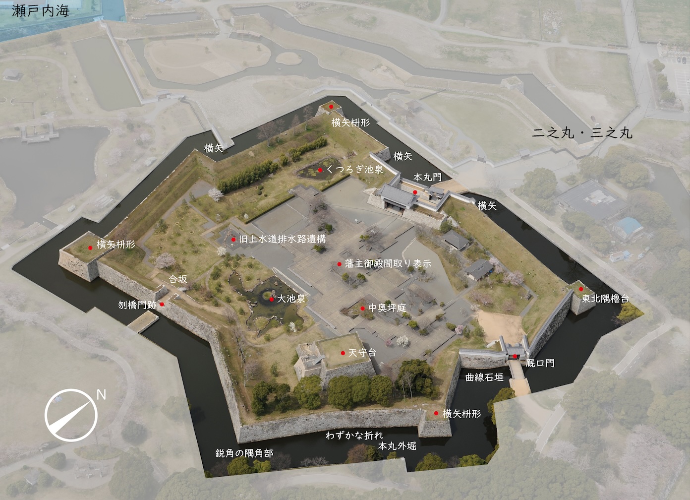
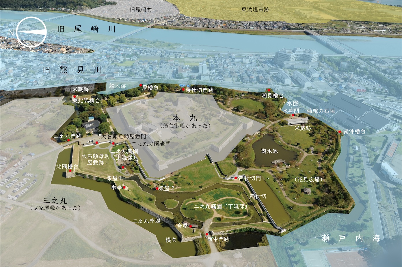
The Layout of Akō Castle
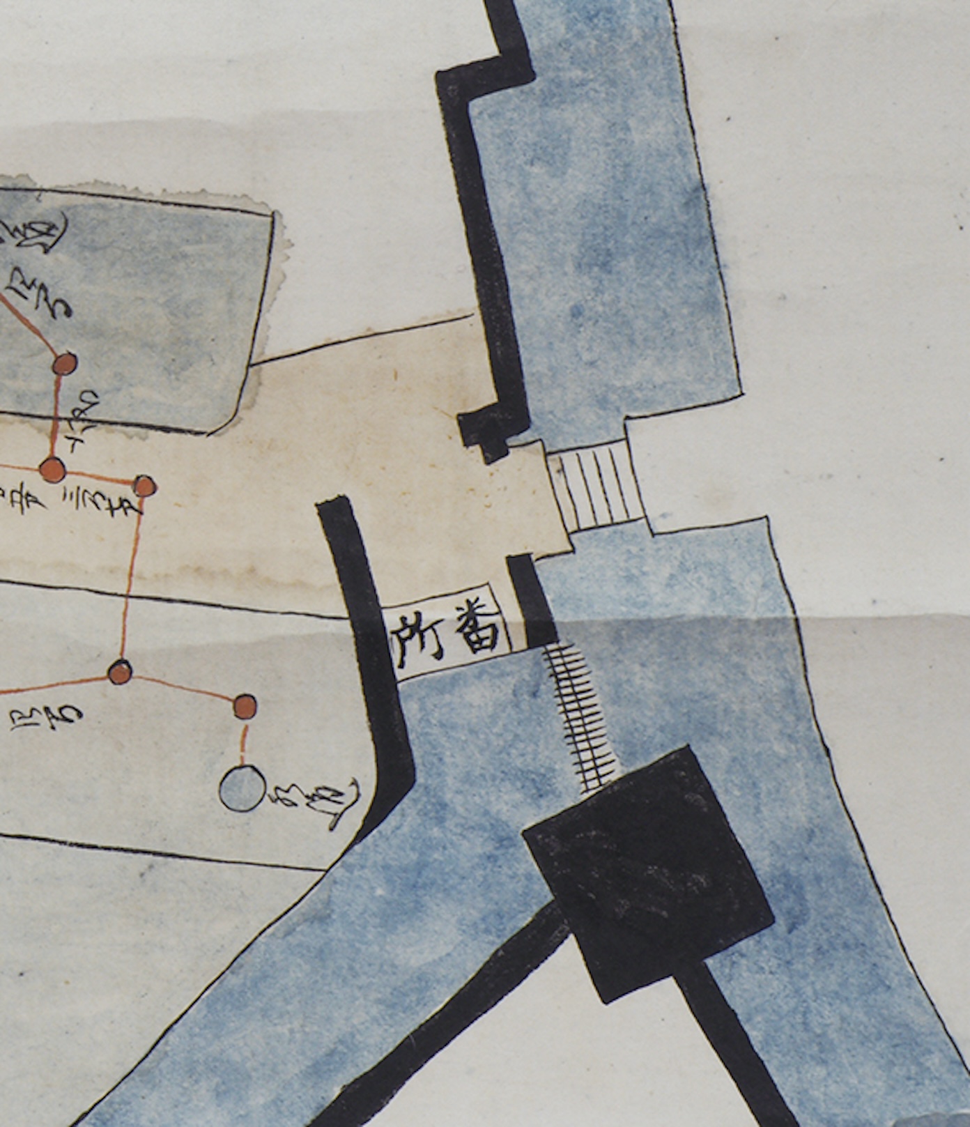
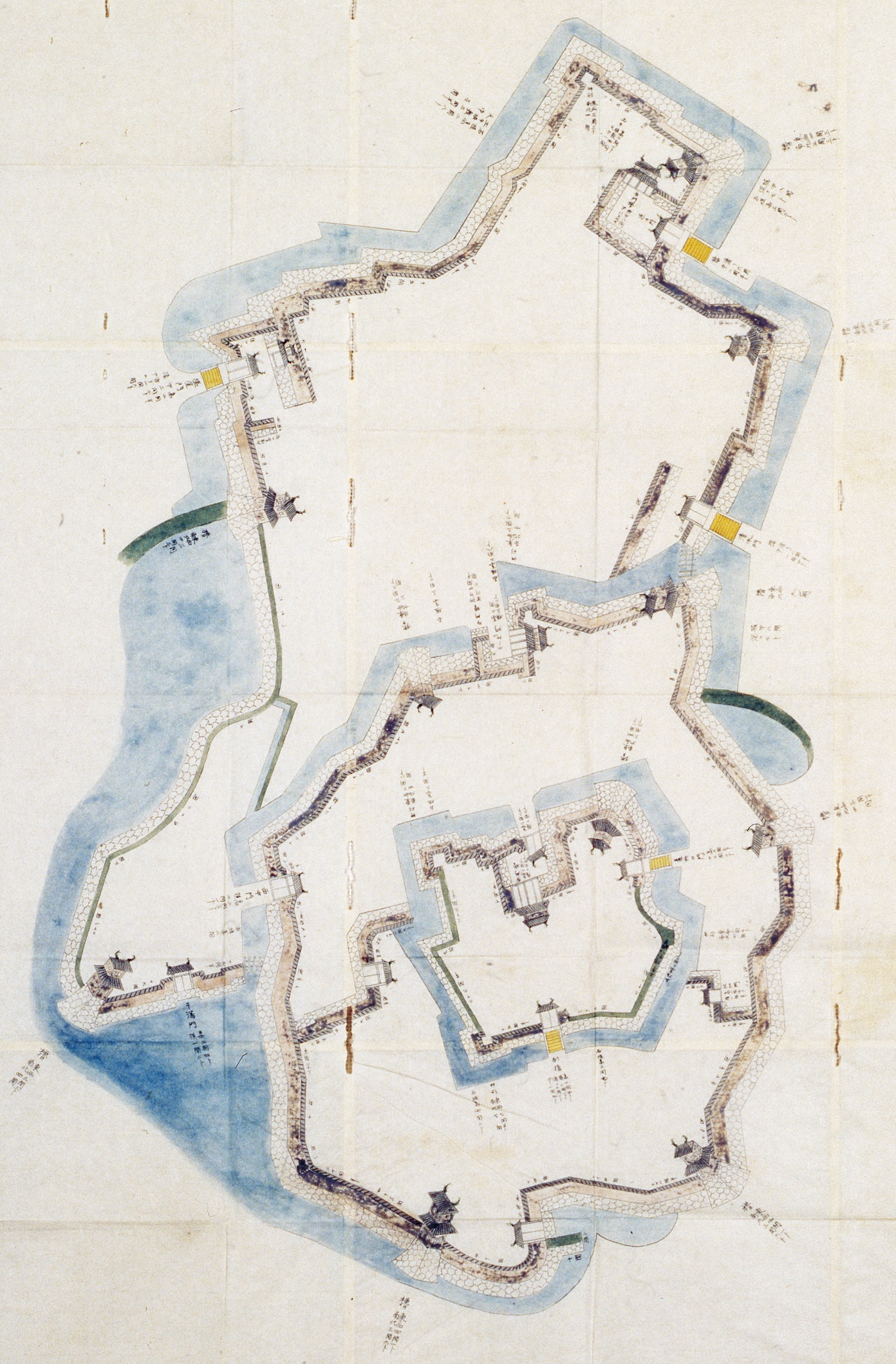 Map of Kariya Castle in Banshū Akō: The gates and stone walls are drawn out and labeled with their scale and length. Upon comparing this map to similar diagrams, it is believed that 1-ken is equal to 6-shaku 5-sun on this map. This is the oldest map among those that only depict Akō Castle.
The Position and Arrangement of Akō Castle
Akō Castle was at the upper plain of the Kumamigawa river delta. To the east of the castle was Kumamigawa River, and to the south and west were the Seto inland sea and tidelands, making it both a water and lowland castle. Kumamigawa River and the tidelands were natural fortifications that made it impossible for large ships to approach the castle. The castle town protected the remaining northern portion of the castle, which had many temples located all over as a defensive measure.
Additionally, the castle was arranged to utilize the natural terrain to focus defenses on its weakest point, the northern side. The Honmaru had the lord’s palace and a tenshu tower base. The Ninomaru surrounded the Honmaru in a rinkaku-style (concentric) structure. In contrast, the Sannomaru was built to the north in a teikaku-style structure, where the Honmaru is traditionally placed adjacent to castle walls. This gave the castle what should be called a "modified rinkaku-style" layout.
10 yagura (turrets) and 12 gates were also built for defense. 8 of the 10 yagura were built on the castle's perimeter, giving it a dignified appearance. Ōtemon gate, which was the main route into the castle, Ninomarumon gate, and Honmarumon gate were yaguramon-style gates. Many of the other gates were kōraimon-style gates.
The Honmaru
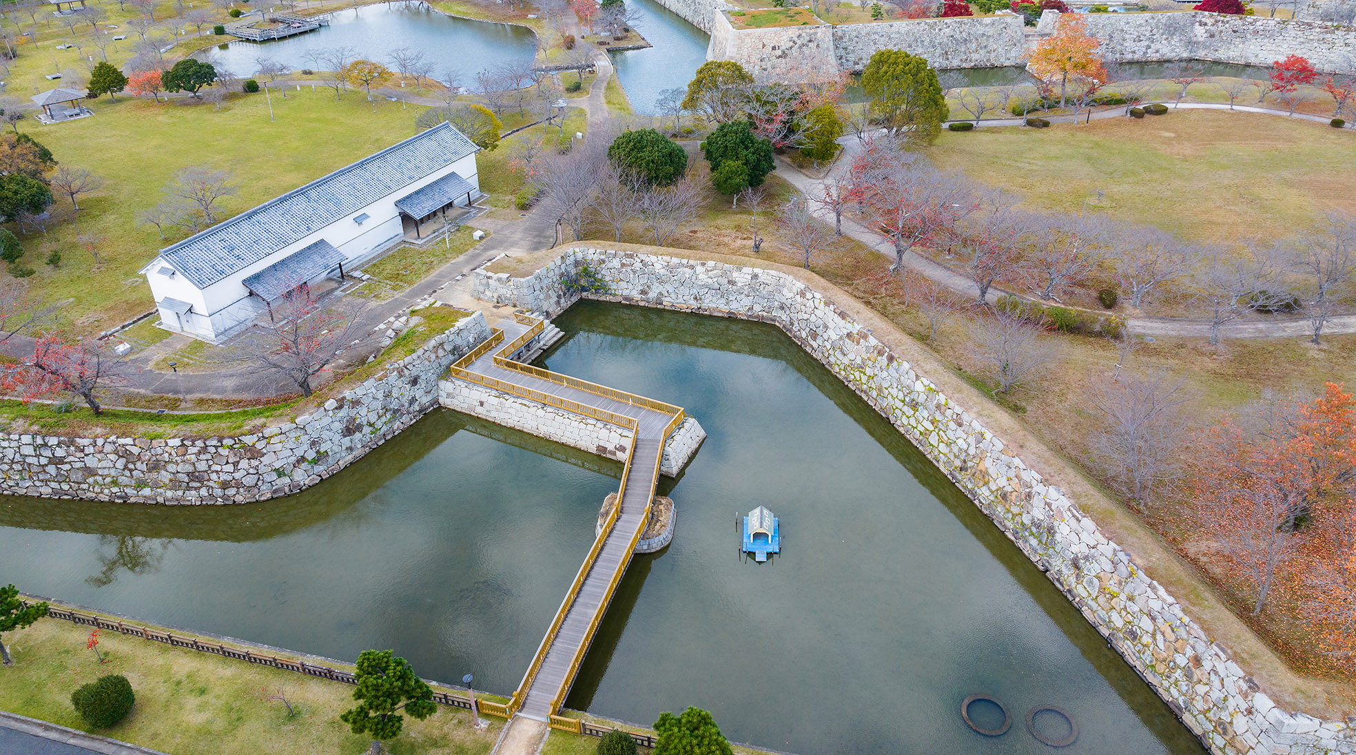
 【Akō Castle Ruins: The Honmaru】The stone walls of the Honmaru were constructed with yokoya gakari, a defensive construction pattern that made attacking from every direction possible, which led to an incredibly complex structure. There was only one sumi-yagura (corner turret), but yokoya masugata, a square-shaped configuration that served a similar purpose, were located on all sides of the Honmaru walls.
The Honmaru Layout
At first glance, the Honmaru appears to be rectangular when in two dimensions. However, looking closely, you’ll see its incredibly complex structure influenced by war tactics. There was a two-story sumi-yagura in the northeastern corner and yokoya masugata configurations jutting out from the western, southern, and eastern sides. The stone walls were also constructed in a complex zigzag pattern known as ore, which formed multiple yokoya gakari. The stone walls extending south from Umayaguchimon Gate also had yokoya masugata, which gave the wall a gentle curve. Further south, the walls had slight ore, giving the corner a bit of an acute angle. These various aspects are part of the many highlights unique to Akō Castle.
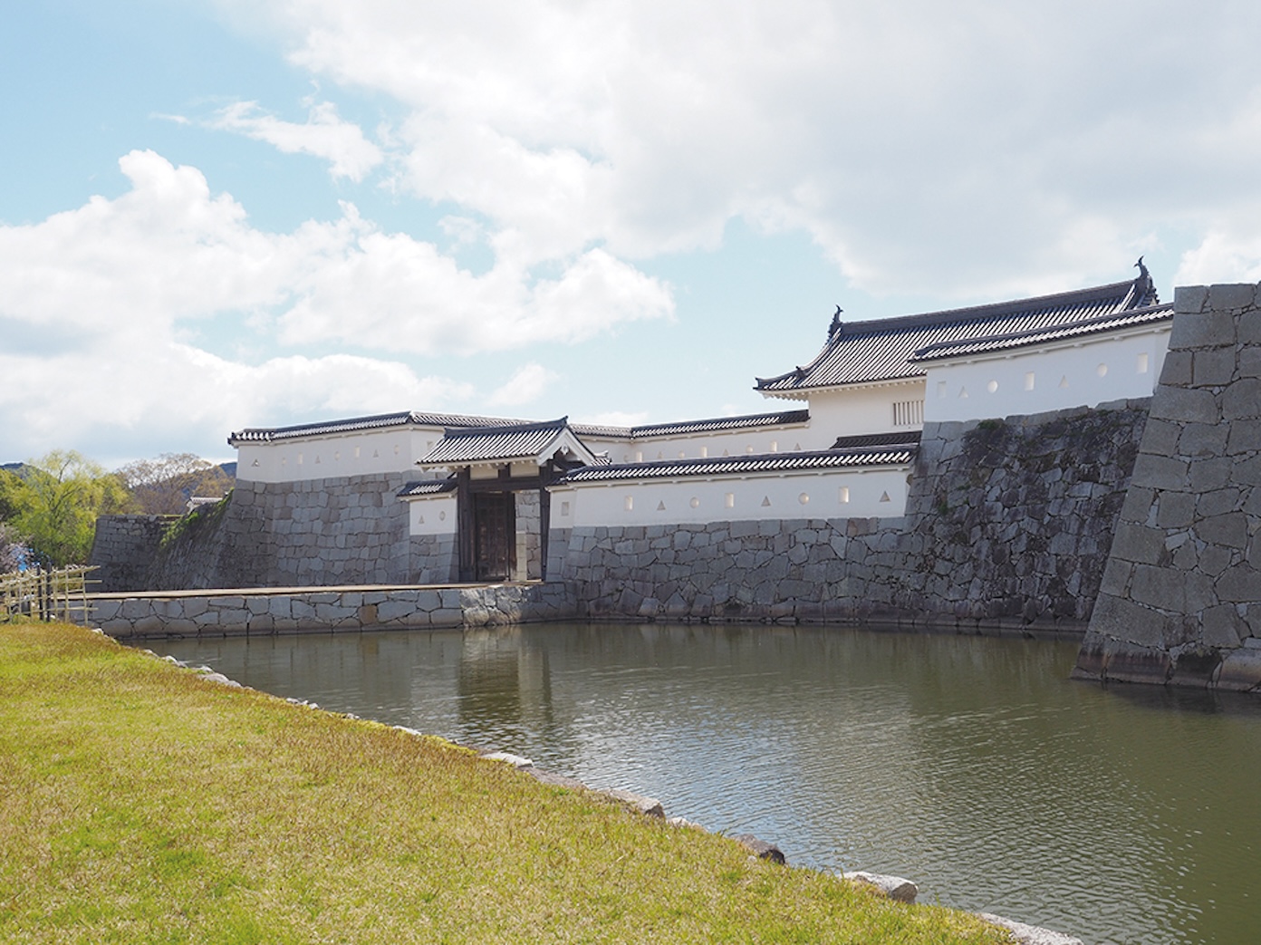
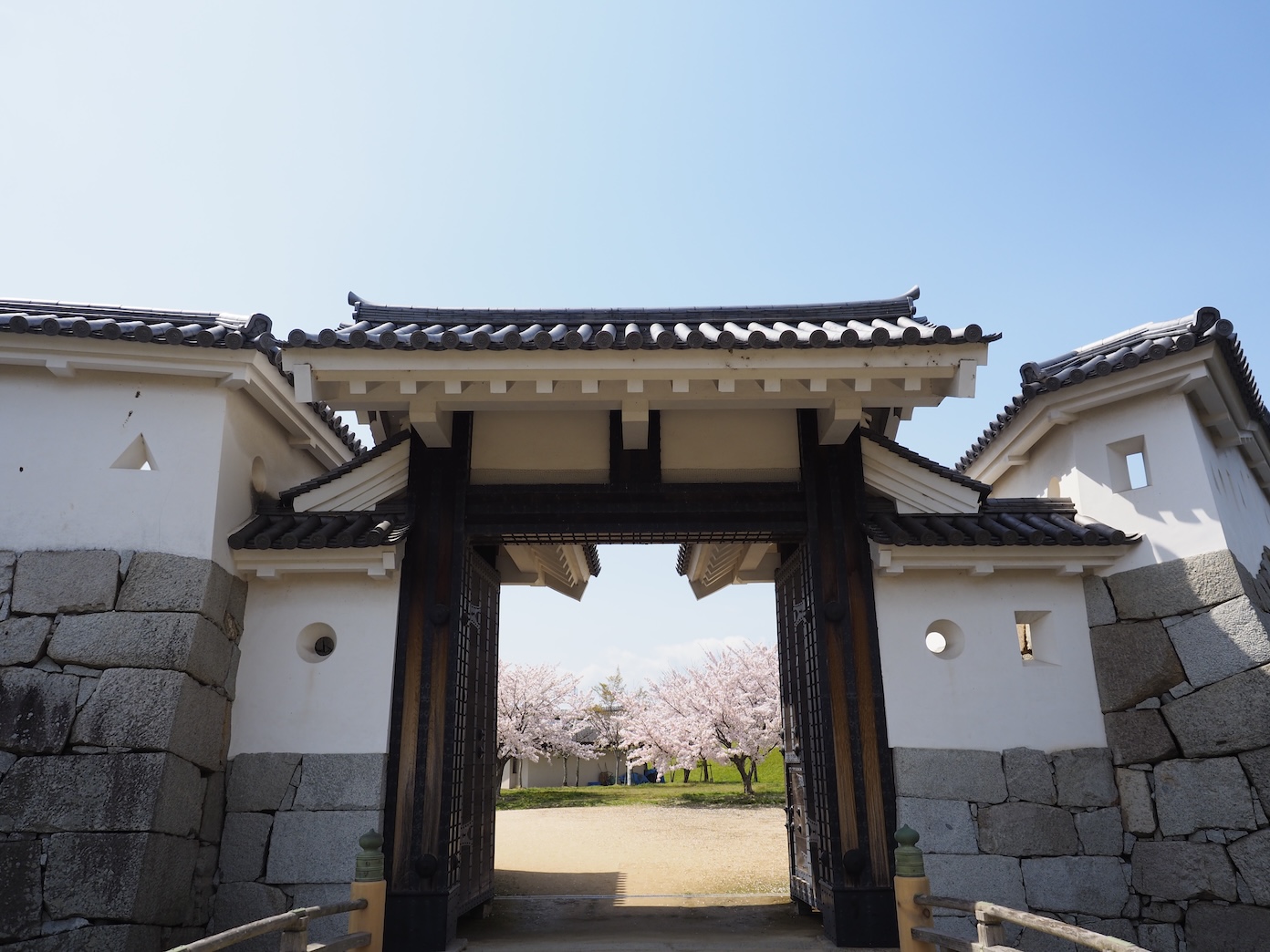
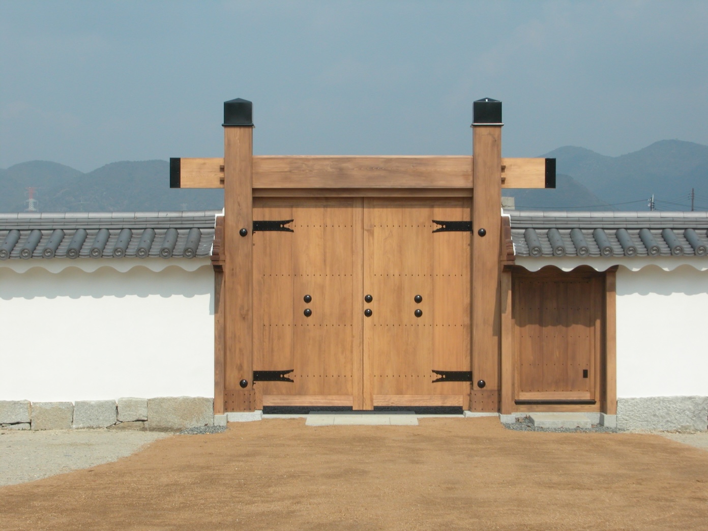
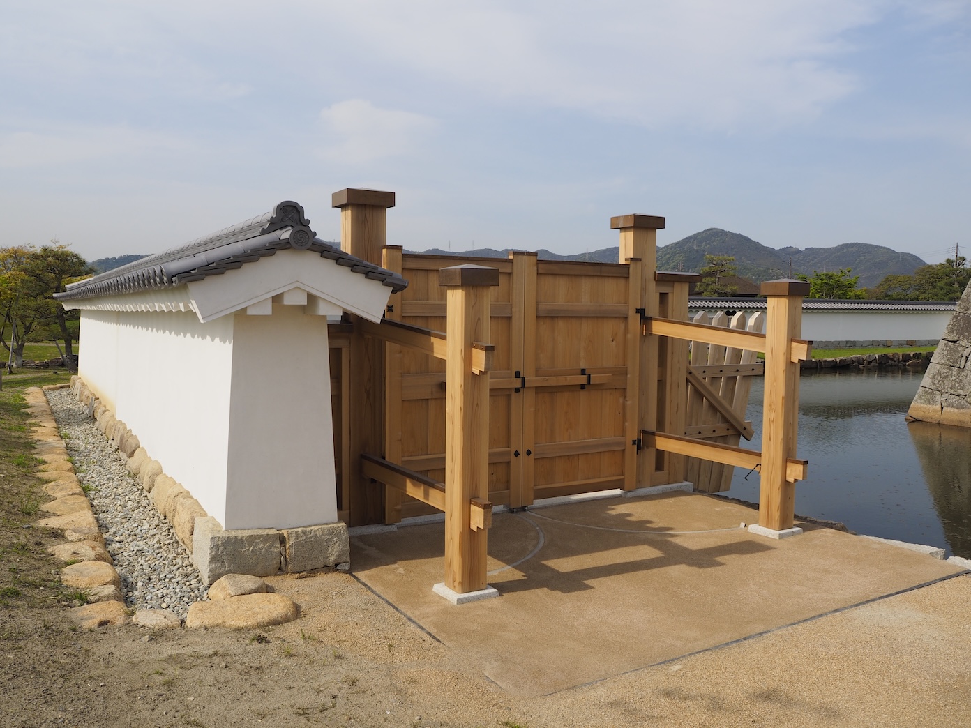
The Honmaru had a total of three gates. The Honmarumon gate comprised two gates: the ichi-no-mon (first gate), which was a yaguramon-style gate, and the ni-no-mon (second gate), which was a kōraimon-style gate. These two gates gave it a sturdy masugata (square) configuration. The second was Umayaguchimon Gate, which was a daidokoromon gate (kitchen access gate) that was used as a service entrance. Finally, there was the Hanebashimon gate, an emergency exit leading south.
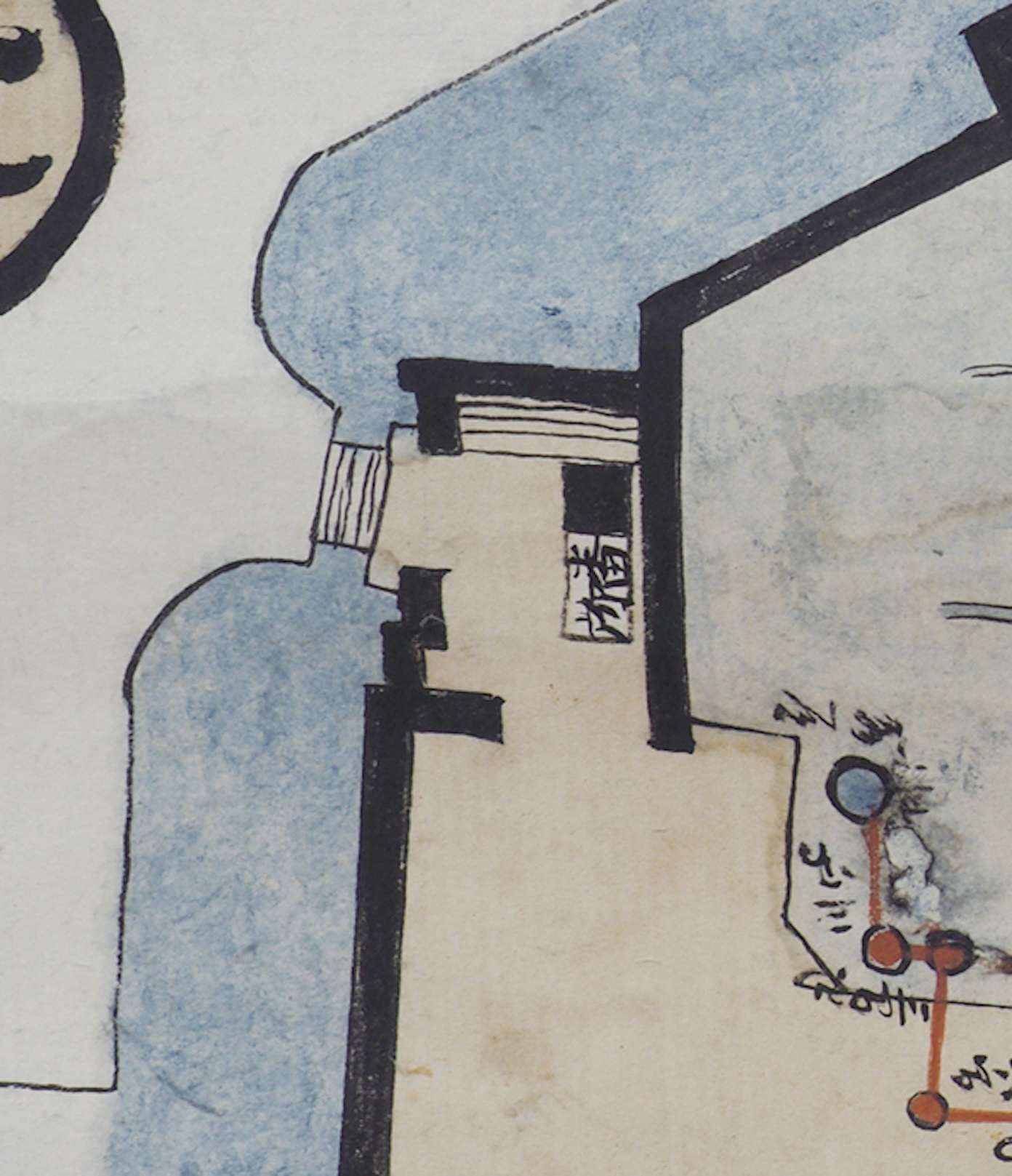
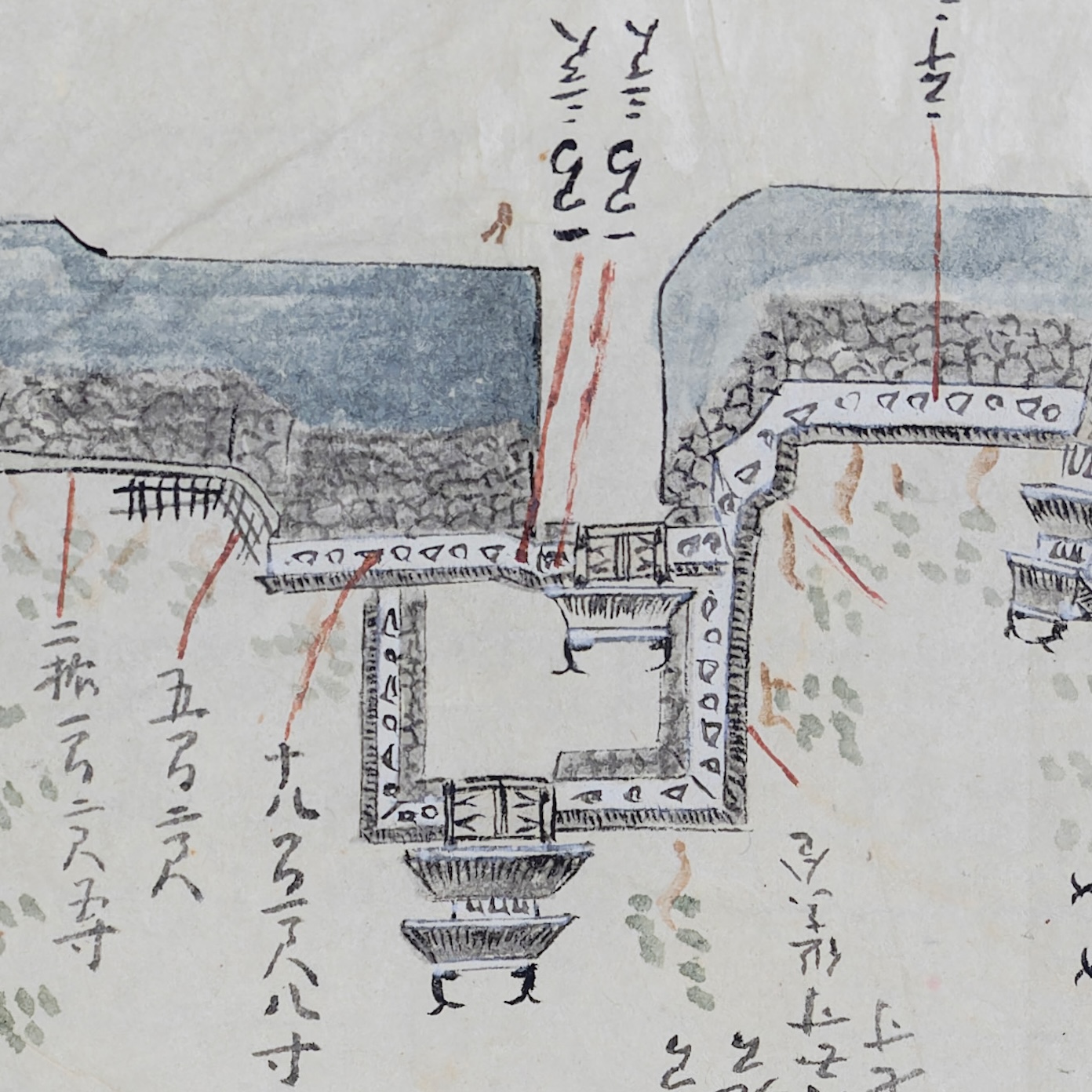 【The Honmaru Masugata Portion of “Akō Castle Map” (Property of Aoyma Kumiko)】The most illustrative map of Akō Castle. There are two gates, and the map shows that the second is a two-story yaguramon-style gate.
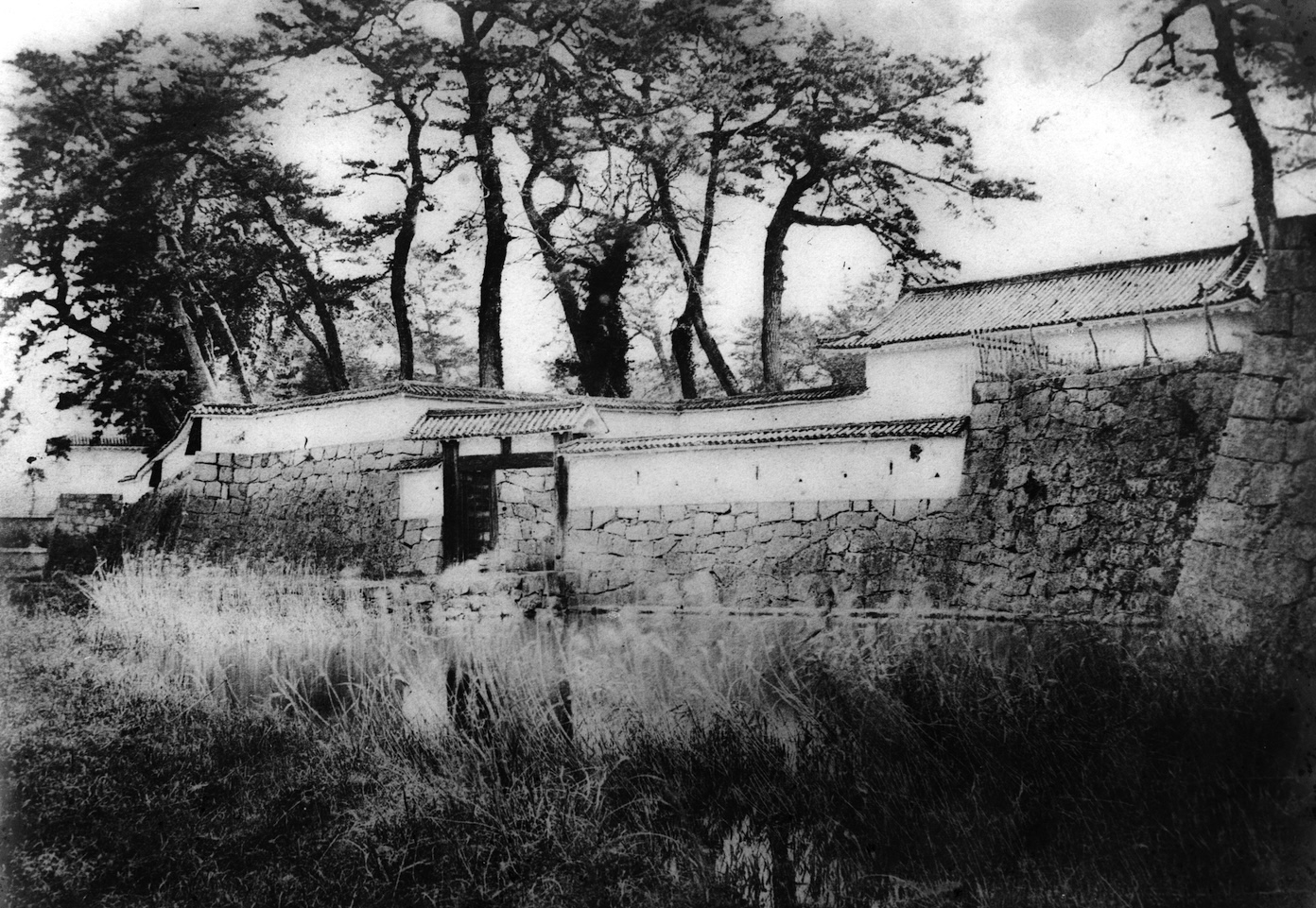
 【Old Photographs of Honmarumon Gate at Akō Castle (Negatives are Property of Kagakuji Temple)】The photos above were taken sometime between 1877 and 1886. The photo on the right is the gate in its current repaired state.
The Tenshu Tower Base
A tenshu tower base was built adjacent to the southeast of the lord’s palace. The base measured 8-ken from east to west and 9-ken from north to south. The base had a height of 3-jō 1-shaku 5-sun (~9.5m).
A tenshu tower was never built at Akō Castle, but upon climbing onto the base, you would have a broad, clear view of the Seto inland sea spanning from the west to the south. You would have also seen the salt fields to the east and the castle town to the north.
In prewar times, the corners of the base had remained destroyed. The base was repaired in 1937, which led to the tenshu tower base we have today.
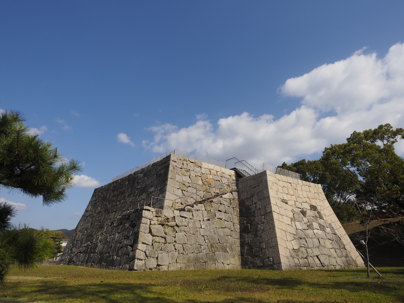 【The Honmaru Tenshu Tower Base】 The corners have been repaired, but the rest of the base has maintained its original state.
The Feudal Lord’s Palace
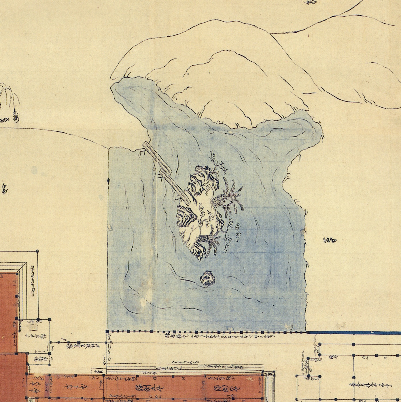
The feudal lord’s palace took up most of the Honmaru. According to “Diagram of the Akō Castle Honmaru” (see left), which shows the castle's state in 1701, the lord’s palace made up over a third of the Honmaru rounds. There were three additional buildings located in the Honmaru.
The feudal lord’s palace was split into the omote, where the lord would conduct official business; the nakaoku, where the lord resided; and the oku, which housed the lord’s family, concubines, and female staff.
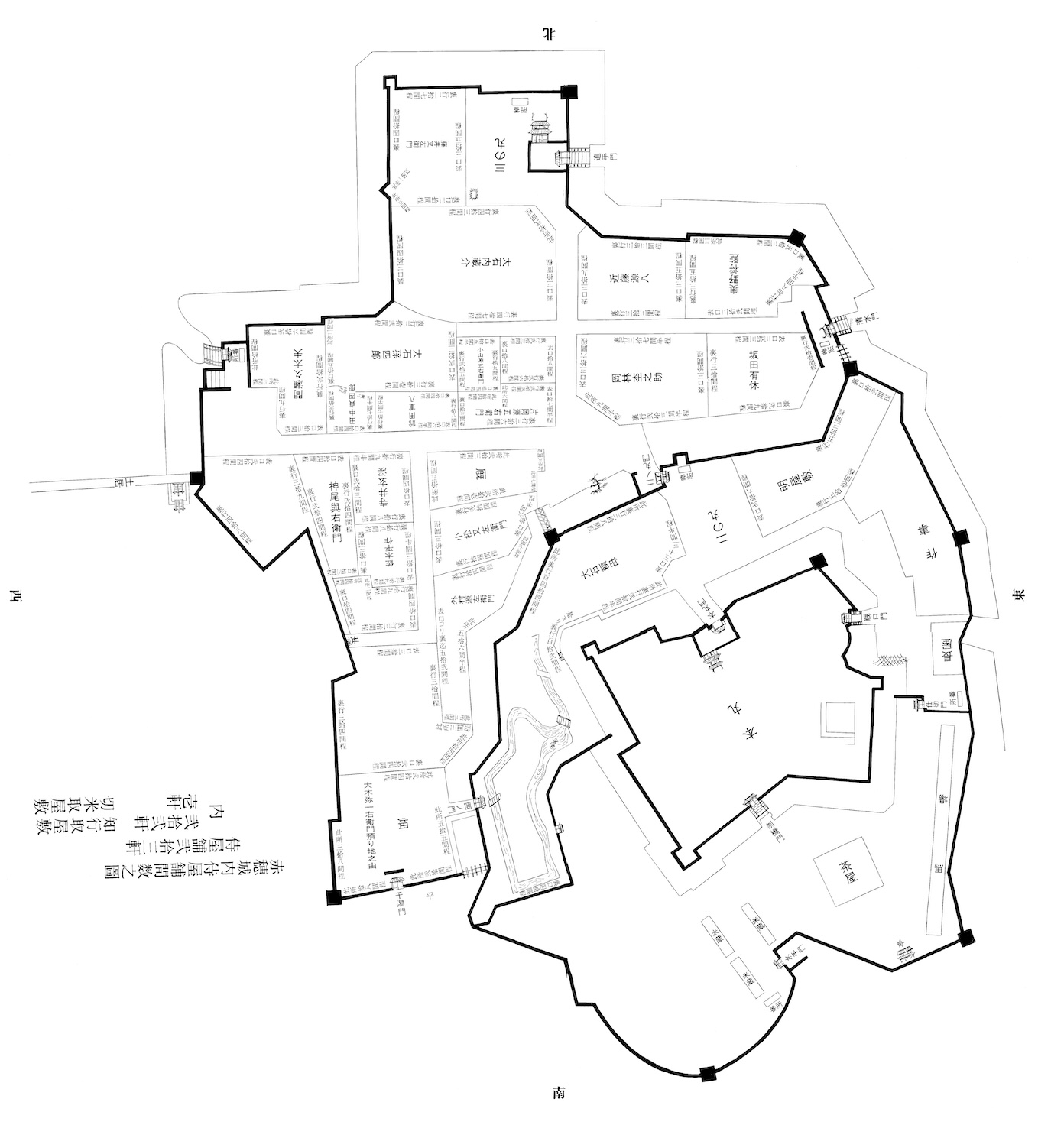
 【Diagram of the Akō Castle Honmaru (Property of Tatsuno Municipal History and Culture Museum)】The Wakisaka clan of Tatsuno Domain created this map during the surrender of Akō Castle. The map features a detailed layout of the Honmaru. The orientation of the Honmaru indicates that the bottom is the north side.
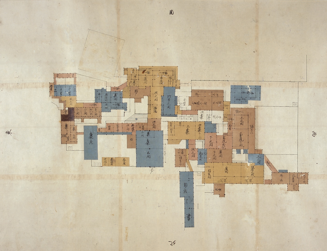
 A floorplan of the palace in the Honmaru from the late Edo period. The palace was renovated in 1861. Compared to a diagram of the palace from the Genroku era, this floorplan shows that some of the original buildings were left untouched while the overall palace was scaled down.
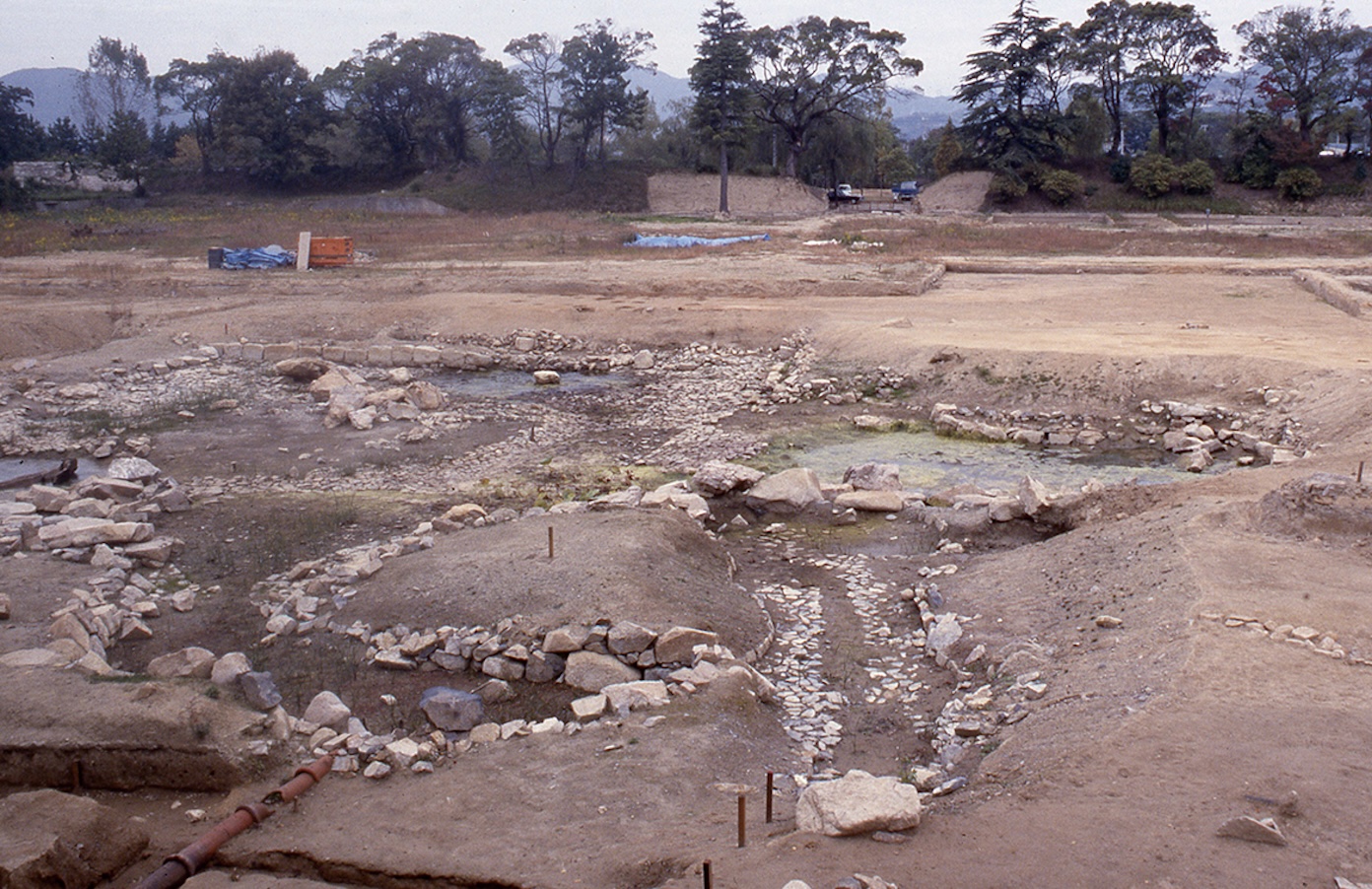
Excavation of the Honmaru Ruins
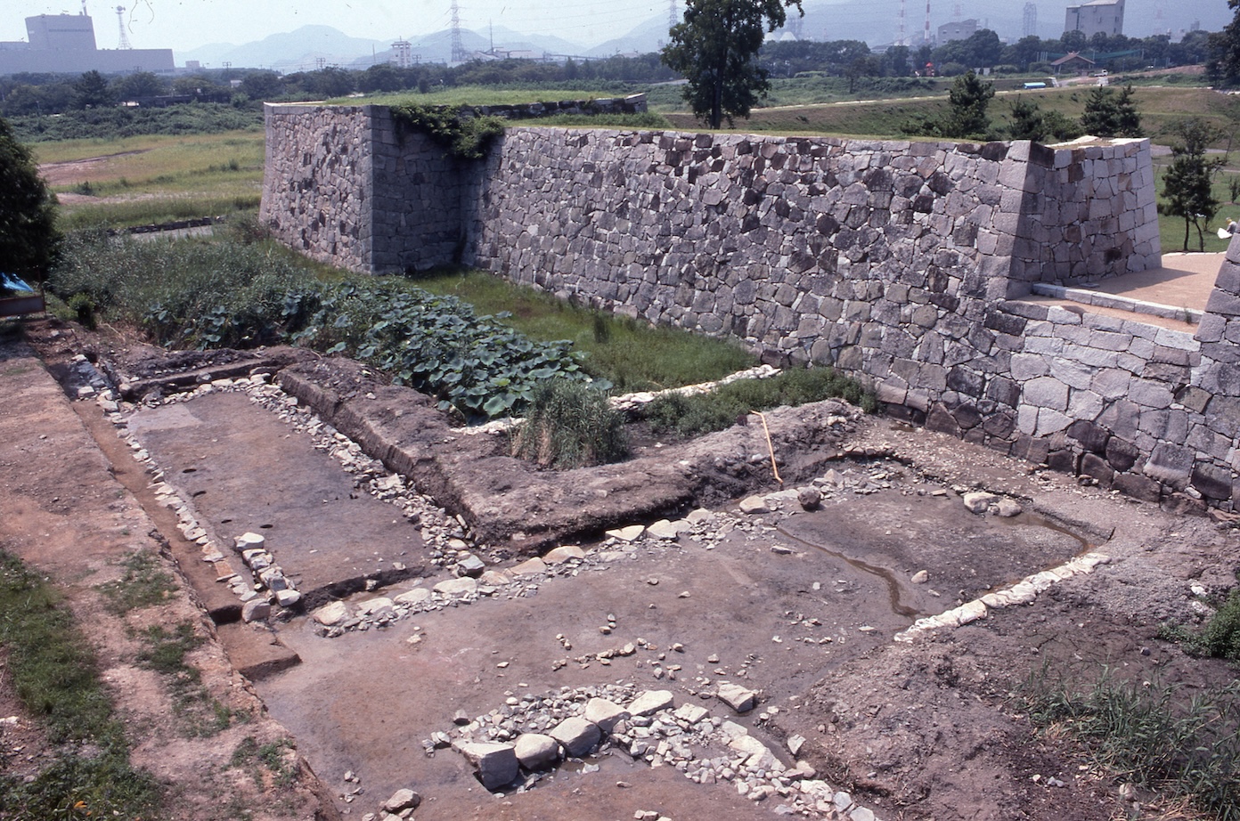
Until 1981, Akō High School stood on the ruins of Akō Castle. The school building was on the site of the Honmaru, and the sports fields were on the site of the Ninomaru. Proper excavation and research began after the campus was relocated.
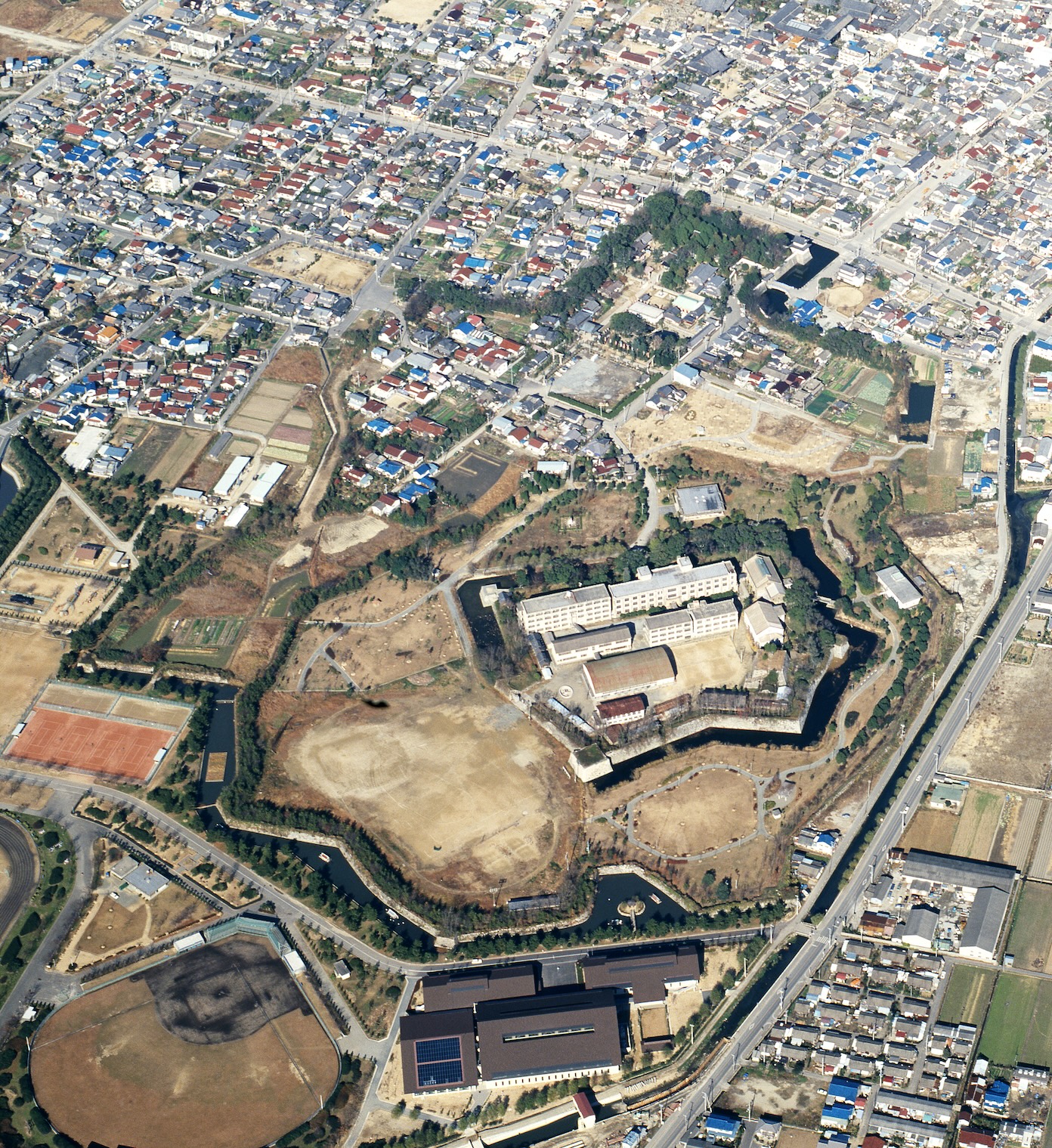 【The Akō Castle Ruins (1975-1984)】 The school building of Akō High School was on the Honmaru site, and the Ninomaru site was used for sports fields. Additionally, many residences were still located on the former castle grounds.
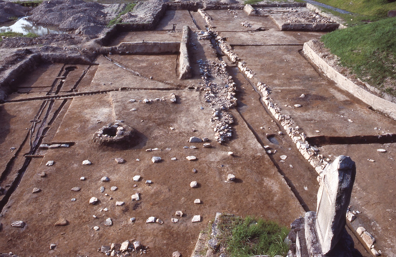 【Excavation Efforts at the Honmaru Ruins】Most of the palace center hadn’t survived, but the cornerstone was found in excellent condition in the areas where the school building of Akō Public High School wasn’t standing..
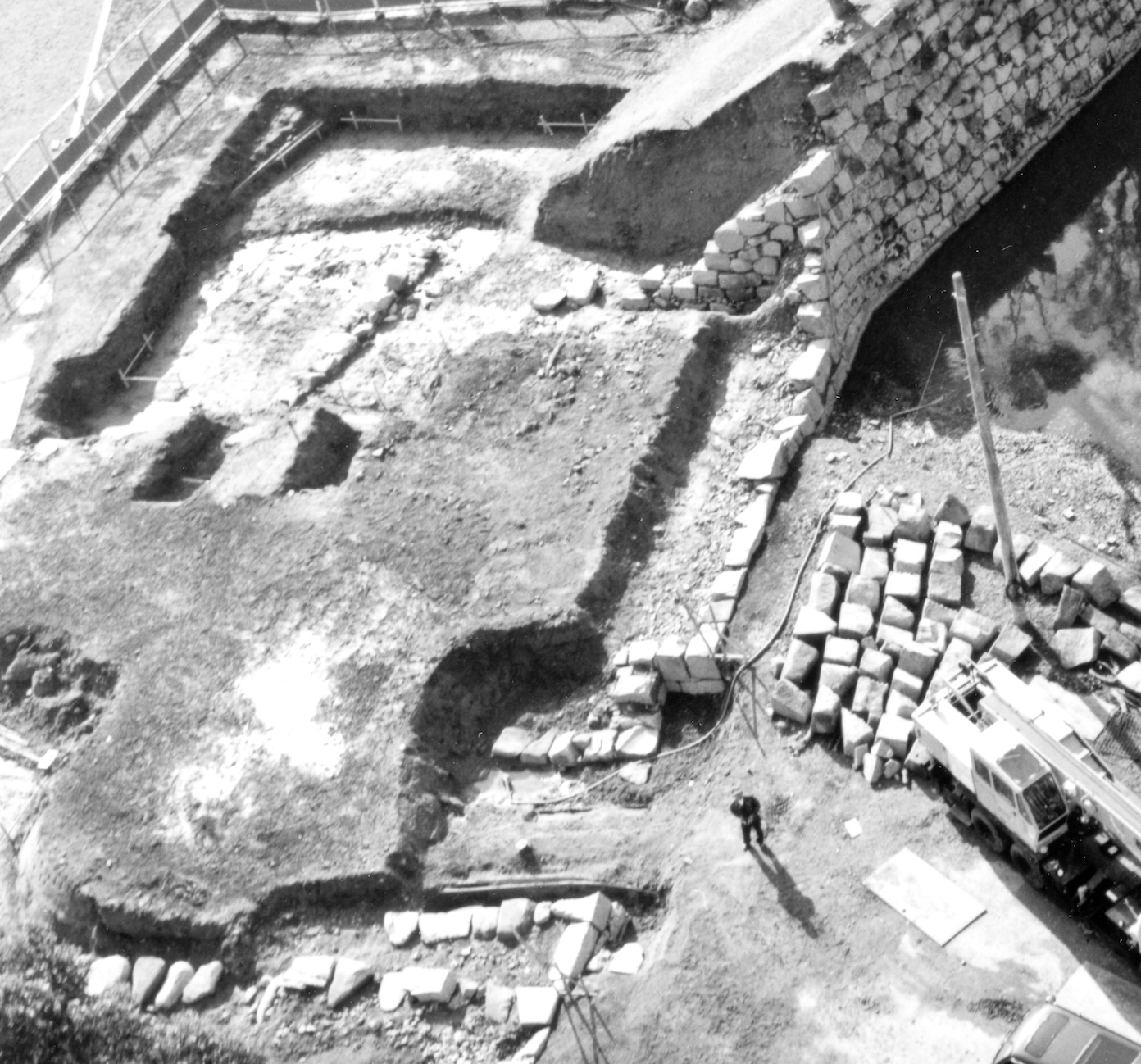
Excavation efforts began in 1983 and continued until 2001, when repairs were made to Umayaguchimon Gate. Despite the researcher’s efforts, only a few relics tied to the lord’s palace were excavated from the former school building.
However, the excavation efforts still saw great results. Parts of the Honmaru were excavated, such as the garden pond, which was lower than ground level at the time, and the northern side of the tenshu tower base. Currently, the floorplan of the feudal lord’s palace is displayed at full scale. You can walk through the floorplan and experience the true scale of the palace.
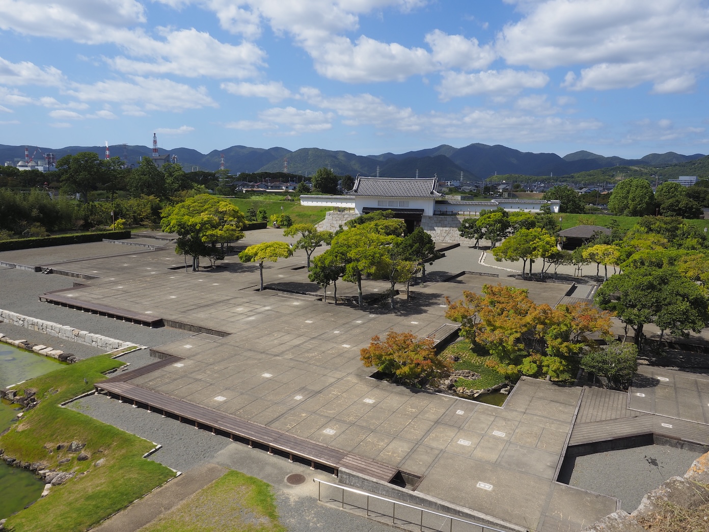 You can experience the true scale of the palace through the display, which shows everything at full scale based on the size of individual tatami mats and flooring planks depicted in diagrams.
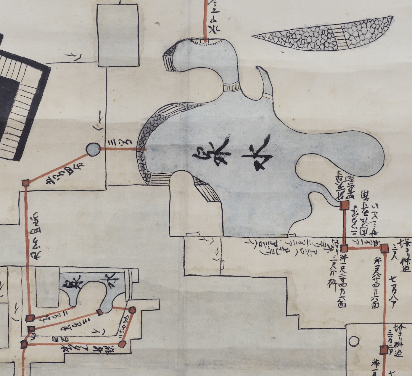
The Honmaru Gardens
A large pond and gardens were constructed facing the southern side of the lord’s palace. Initially, the pond was rectangular, with two inlets. According to maps of the gardens, there was a pond island with a Japanese sago palm planted at the center. The pond was surrounded by white sand. The gardens were built to be viewed from the lord's living room and were obscured by the lord's audience hall lattices. This indicates that the garden was constructed for the feudal lord’s enjoyment.
The garden pond was renovated after the end of Asano control during the rule of the Mori clan. Maps and excavation results show that it became a large-scale pond with four inlets. Currently, the pond has been repaired to reflect its structure during both periods while utilizing the remaining structures that have been excavated.
Excavation efforts also uncovered the nakaoku courtyard, depicted in maps from the end of the Edo period, and a relaxation pond in the northwestern area of the Honmaru, which hadn’t been shown on any map. The detailed construction of the gardens was revealed through excavation efforts, which led to the repair of the main pond and the surrounding areas. The Old Akō Castle Gardens have been collectively designated as a National Place of Scenic Beauty.
 【Excavation of the Honmaru Garden Site】
The bank of the garden pond was found in extremely excellent condition, and repairs today utilize this recovered structure.
【Excavation of the Honmaru Garden Site】
The bank of the garden pond was found in extremely excellent condition, and repairs today utilize this recovered structure.
 【The Honmaru Gardens’ Water Supply Facilities】 Water was supplied to the gardens through Akō Waterworks.
 【Map of the Honmaru Garden Pond. “Diagram of the Akō Castle Honmaru.” (Property of Tatsuno Municipal History and Culture Museum)】 Water was supplied to the gardens through Akō Waterworks.
 【Map of the Honmaru Garden Pond. “Diagram of Akō Castle Honmaru Waterworks.” (Property of Akō High School.)】Water was supplied to the gardens through Akō Waterworks.
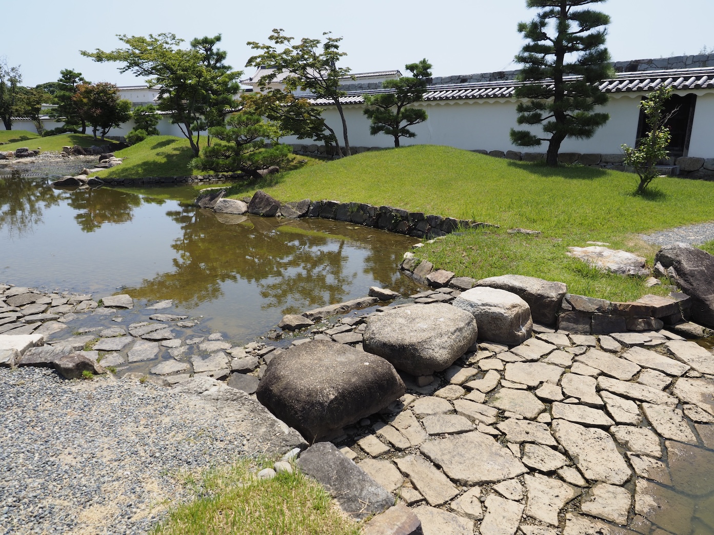
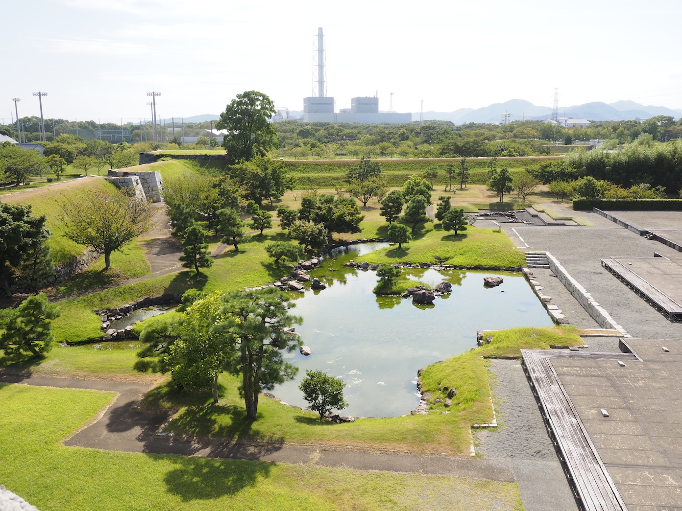 【The Honmaru Garden Pond】 A pond that spanned an impressive 40 meters from east to west and was located south of the feudal lord’s palace. Repairs are based on the results of excavation efforts and reflect the pond as it was during both Asano and Mori rule.
Studying the Gate Sites
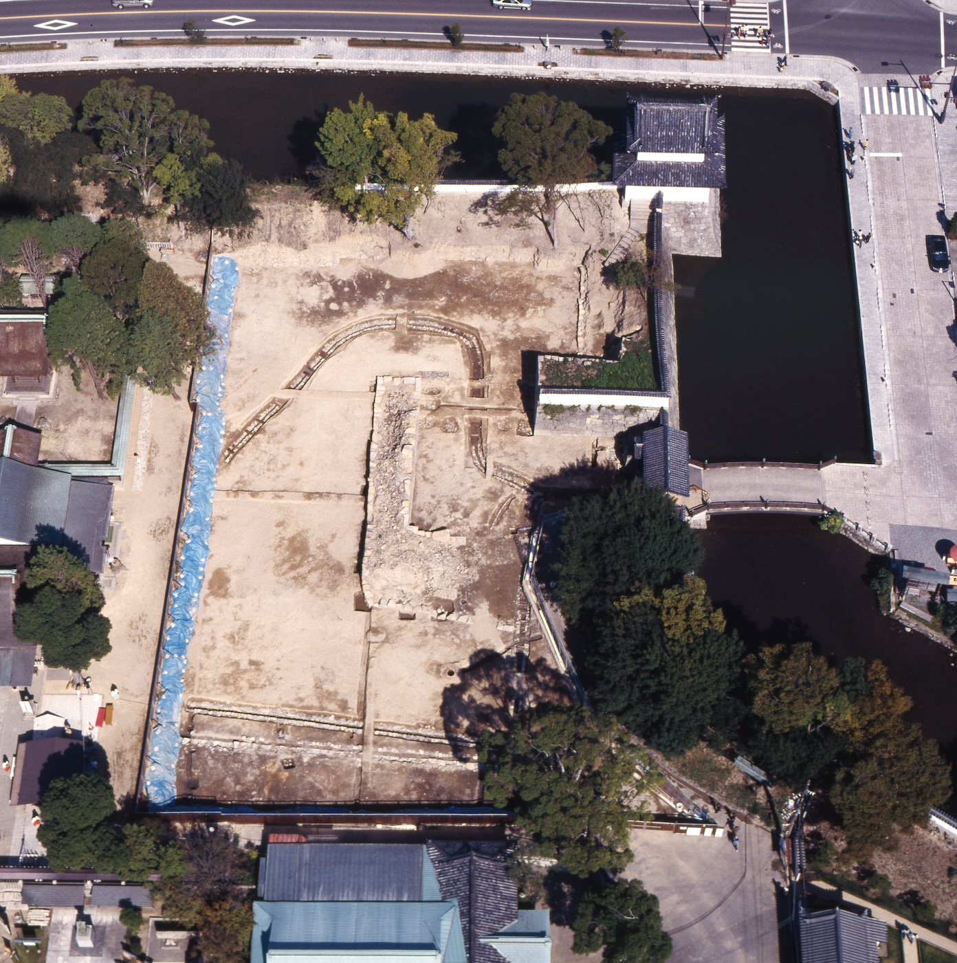
There were excavation efforts at the sites of the Honmarumon, Umayaguchimon (the gate leading to the kitchen), and Hanebashimon gates. Honmarumon Gate sustained heavy damage, as it was the site of Akō Public High School’s gates. However, researchers excavated the side stone walls and a portion of the stone wall that made up the masugata. Additionally, by comparing the site to maps and old photographs, researchers were able to determine the size of the kōraimon-style gate.
 【Excavation Status of Akō Castle Honmarumon Gate Site (As of 1992)】 The stone walls that made up the masugata and the side walls of the ni-no-mon (depicted in the lower-middle area of the image) have been found. The stones on the right side of the photograph are waiting to be used in repairs.
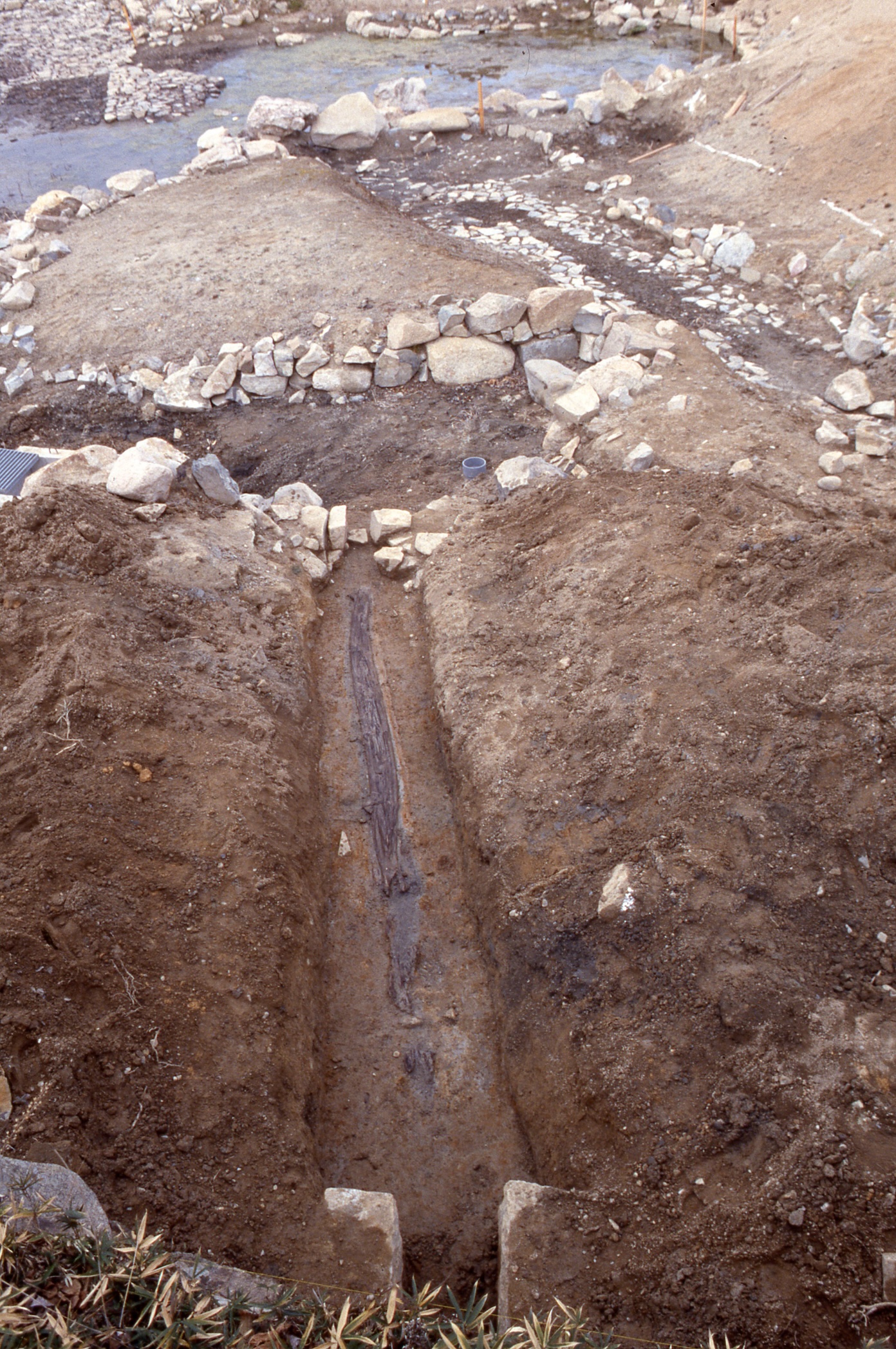
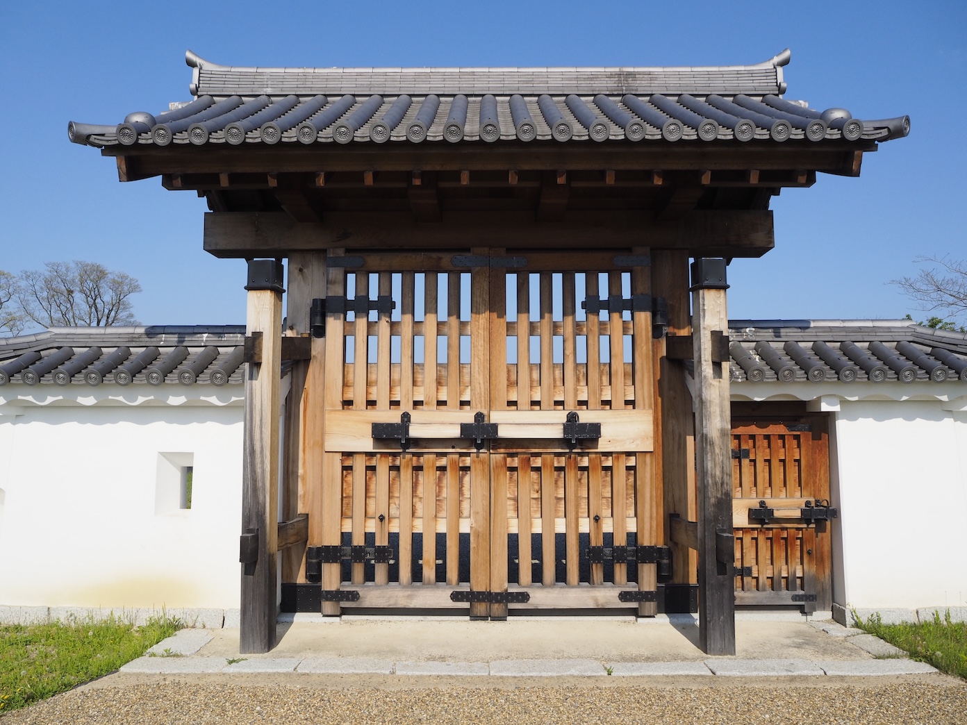
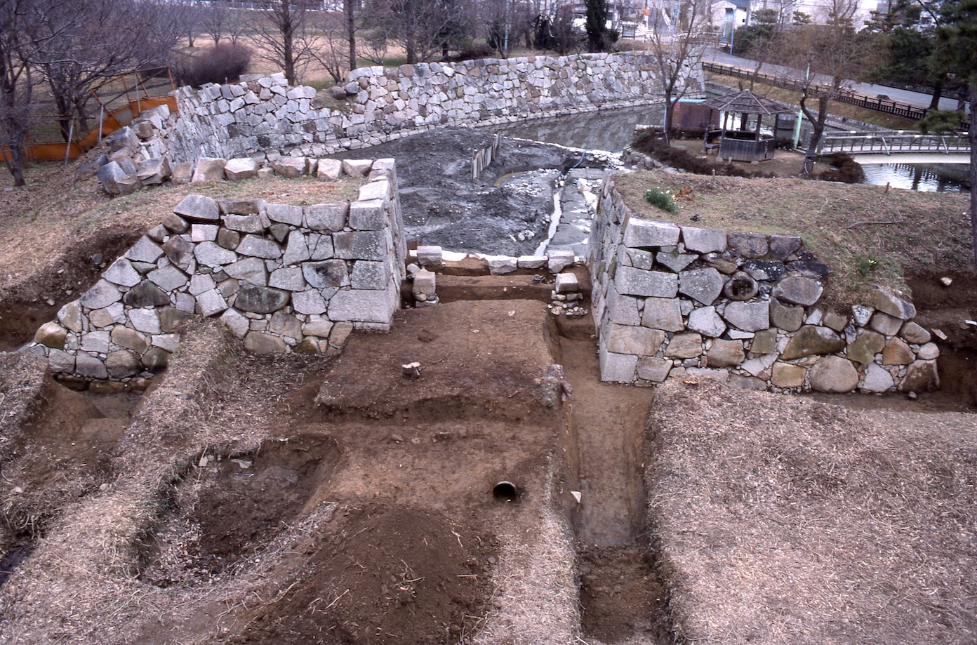
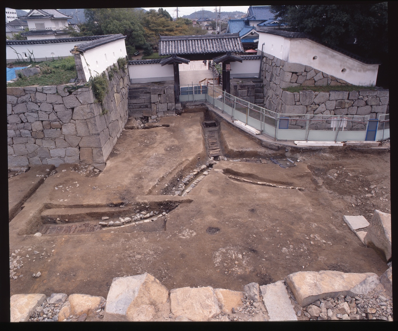
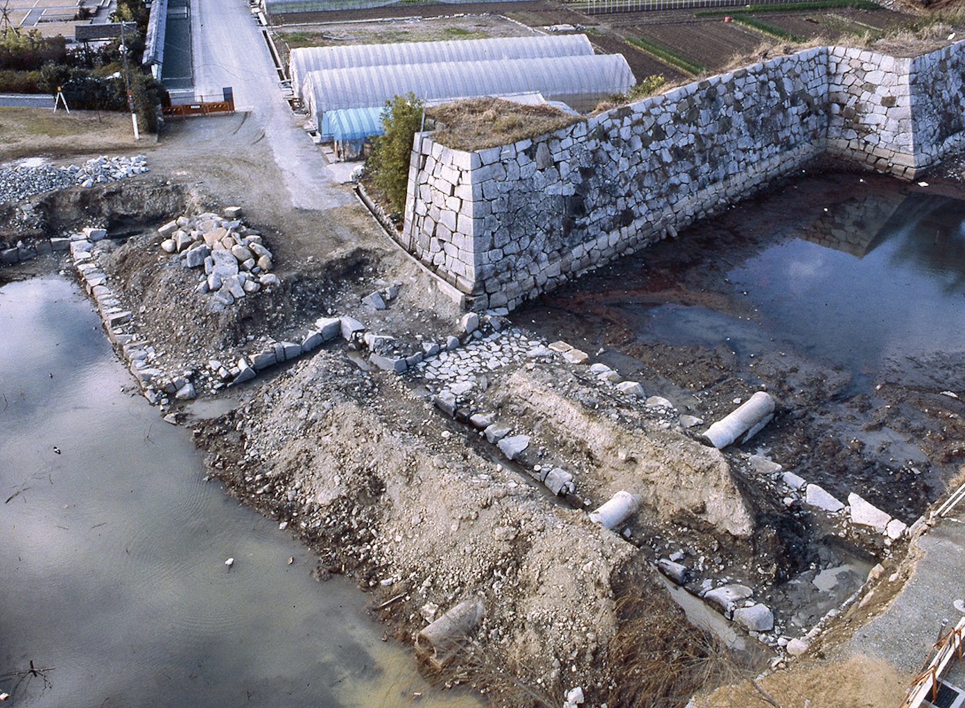
At the Umayaguchimon gate site, excavation efforts yielded results that helped researchers understand the structure of the gate. This included the foundation of the kagamibashira (gate columns), the kamachi stones used to connect the columns to the foundation, the side walls of the gate, and evidence that the supporting columns were removed. The gate has been repaired based on these research materials.
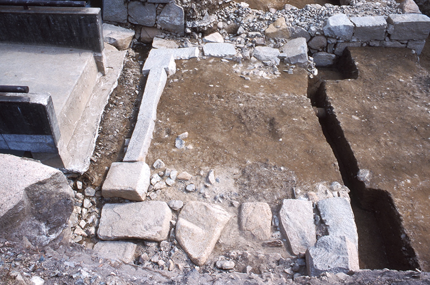 【Excavation of the Honmaru Umayaguchimon Gate Site】The kagamibashira foundation was discovered in excellent condition.
 【Umayaguchimon Gate Post-Restoration】
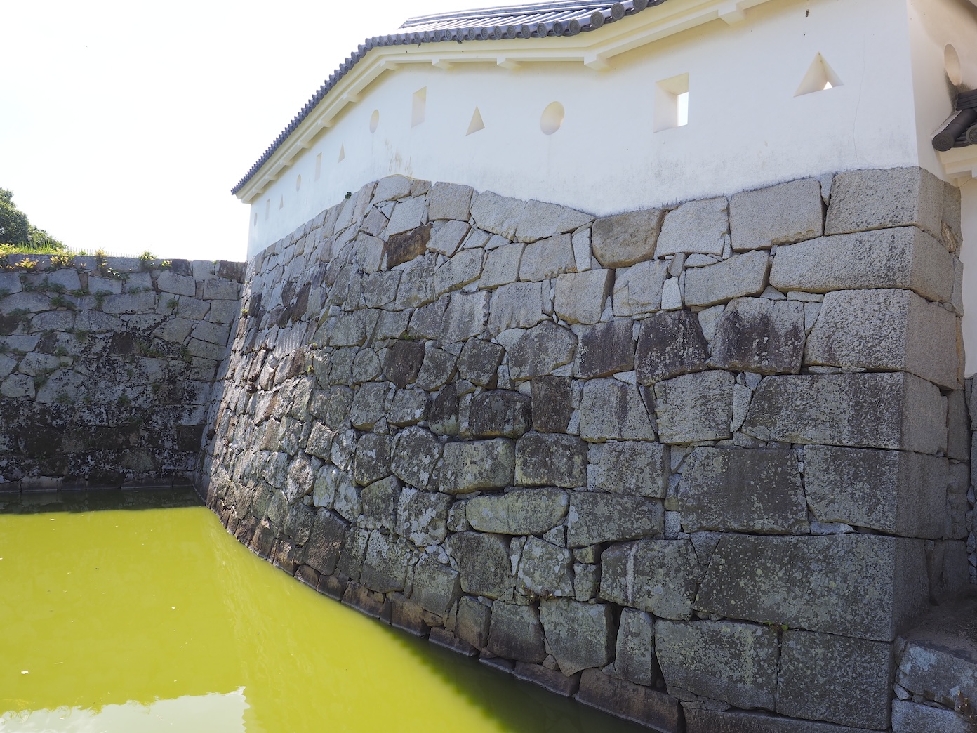 【Curved Stone Walls to the Side of Umayaguchimon Gate】Looking closely, you can see that the stone walls on the southern side of Umayaguchimon Gate are curved. This curve is depicted in castle maps from the Edo period, so we know they hadn’t become slanted over time. The stone walls to the side of Mizutemon gate in the Ninomaru boast a pronounced curve as well. We can see that these structures are important features that tell us how unique the construction of Akō Castle was.
One kagamibashira foundation was also found at the site of Hanebashimon Gate, but the details of the bridge’s construction remain unclear, which has left the structure unrestored.
 【Excavation of the Bridge Abutment on the Shore Opposing Honmaru Hanebashimon Gate 】 Researchers discovered the stone bridge abutment.
The Ninomaru
 The Ninomaru of Akō Castle, a water castle, jutted into the Seto inland sea. To the east and past a river was the Higashihama Salt Field.
The Ninomaru Layout
The Ninomaru was built using rinkaku-style construction, thus surrounding the entirety of the Honmaru. The stone walls were built with a complex zigzag pattern and a variety of yokoya gakari, a defensive structure to attack approaching enemies, a few dozen meters apart. The southern area before Mizutemon Gate had steps and a pier that allowed boats to dock. These structures show how Akō Castle functioned as a water castle. The stone walls surrounding Mizutemon Gate are full of interesting features. Looking closely, you can see the use of the mizuhineri technique, which created large indents in the stone walls, and the curved shape of the wall’s construction.
 【The “Mizuhineri” Technique and Curved Stone Walls】Large indents were created in the stone wall (made using the mizuhineri technique), and a gate was built. The curved stone walls are one of the many highlights of this castle.
The Ninomaru was split into northern and southern sections. The north half was used for samurai residences, and the south half was used for granaries, stables, and communal spaces such as worksheds. The only part of the Ninomaru that was sealed off was the northwestern portion, used for the residence of Ōishi Tanomonosuke Yoshishige, the head chamberlain for the Asano clan. This area was also home to gardens with a large pond (the Ninomaru Gardens).
A total of 5 yagura (turrets) were built at the north, east, and south of the castle. The fact that there aren’t any yagura bases without turrets (in other words, any yokoya masugata) shows that the Ninomaru was an essential part of Akō Castle’s defenses. The Ninomaru had 3 main gates: Ninomarumon Gate, which opened northward and led to the Sannomaru; Nishinakamon Gate (or nishi-no-mon/western gate), which sectioned off the west end of the Ninomaru Gardens; and Mizutemon Gate, which opened southward and led to the Seto inland sea. There were also gates on the east and west sides separating the sections of the Ninomaru.
Ōishi Yoshishige and the Ninomaru Gardens
One of the people who lived in the Ninomaru was Ōishi Tanomonosuke Yoshishige. Yoshishige was the head chamberlain to the Asano clan and was the granduncle of Ōishi Kuranosuke Yoshitaka. Old texts indicate he would be “bestowed residence in the Ninomaru, 4-chō long, and a garden with an artificial hill and pond of an equivalent size.”1 In Yamaga Sokō’s Chronicles, he stated, “On the fourteenth, I visited Ōishi-shi’s garden.”2 There are also records that the lord joined in on the merriment.
Excavation efforts at the site of Yoshishige’s residence uncovered the Ninomaru Gardens, which were over 1 hectare (10,000m2) in size. This was the very same garden that Yamaga Sokō enjoyed.
In 1998, the entire area of the Ninomaru Gardens was excavated, uncovering the gardens in their entirety. The upstream area comprised a complex bank with 3 inlets. The downstream area had a much simpler bank but also brilliant waterways that traveled around the pond island. In Chronicles, Yamaga Sokō also stated, “We pushed out a small boat and drifted along the pond until evening,” which shows that the gardens were large enough to enjoy boating.
The Ninomaru Gardens and the repaired Honmaru Gardens were collectively designated as a National Place of Scenic Beauty under the name “Old Akō Castle Gardens: Honmaru and Ninomaru Gardens.” The gardens are maintained regularly and have been regaining their original landscape.
- Ōishi compilation. “Yoshishige-fu.” Ōishi-ke Keizu Sanyō. 1980.
- Hirose, Yutaka. Yamaga Sokō Zenshū: Shisō-hen. Iwanami Shoten, 1941.
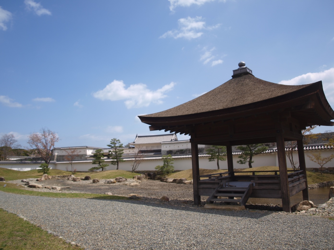 【Azumaya (Pavillion) 1】
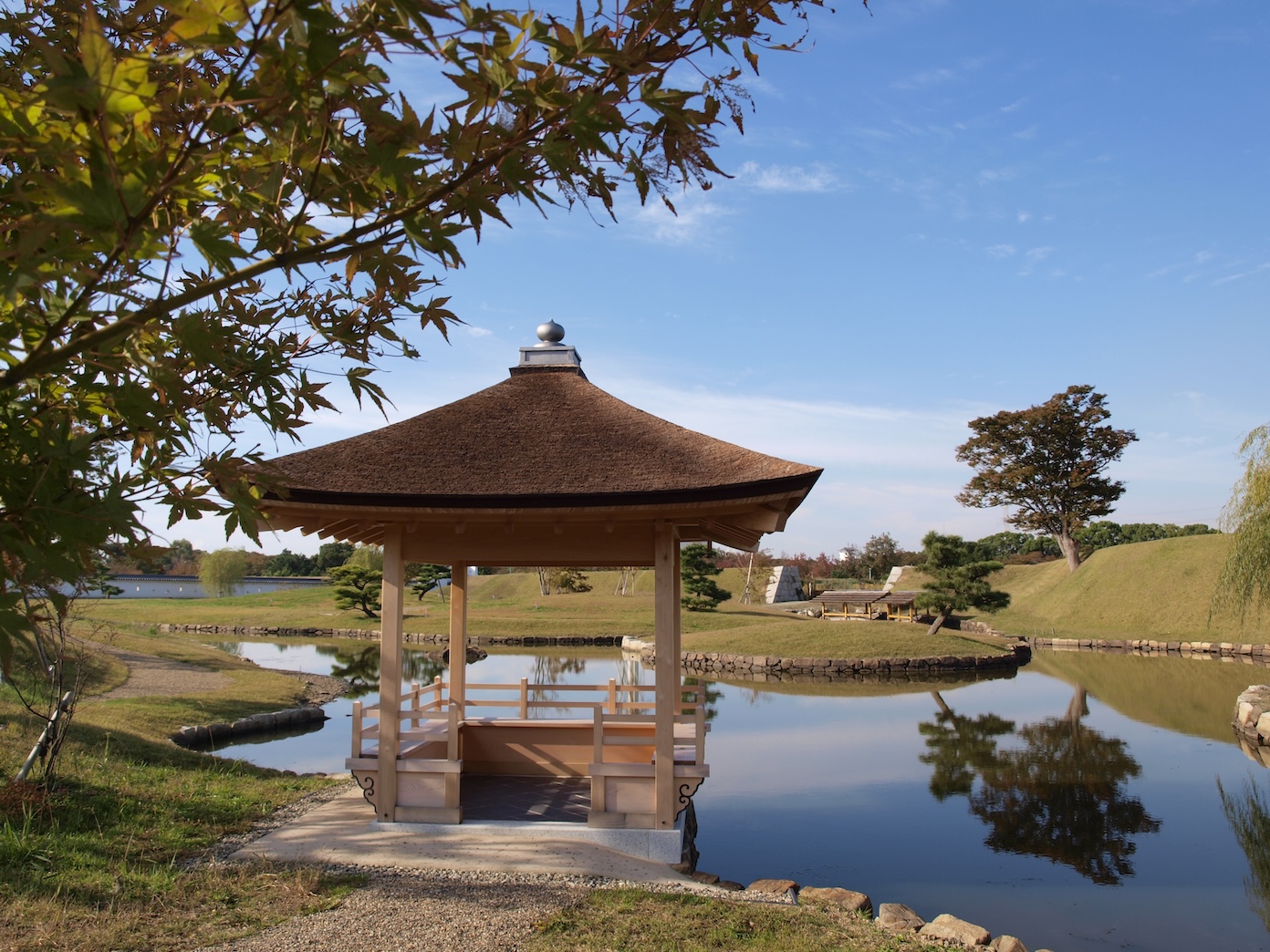 【Azumaya (Pavillion) 2】
 【Garden Pond Upstream Area】
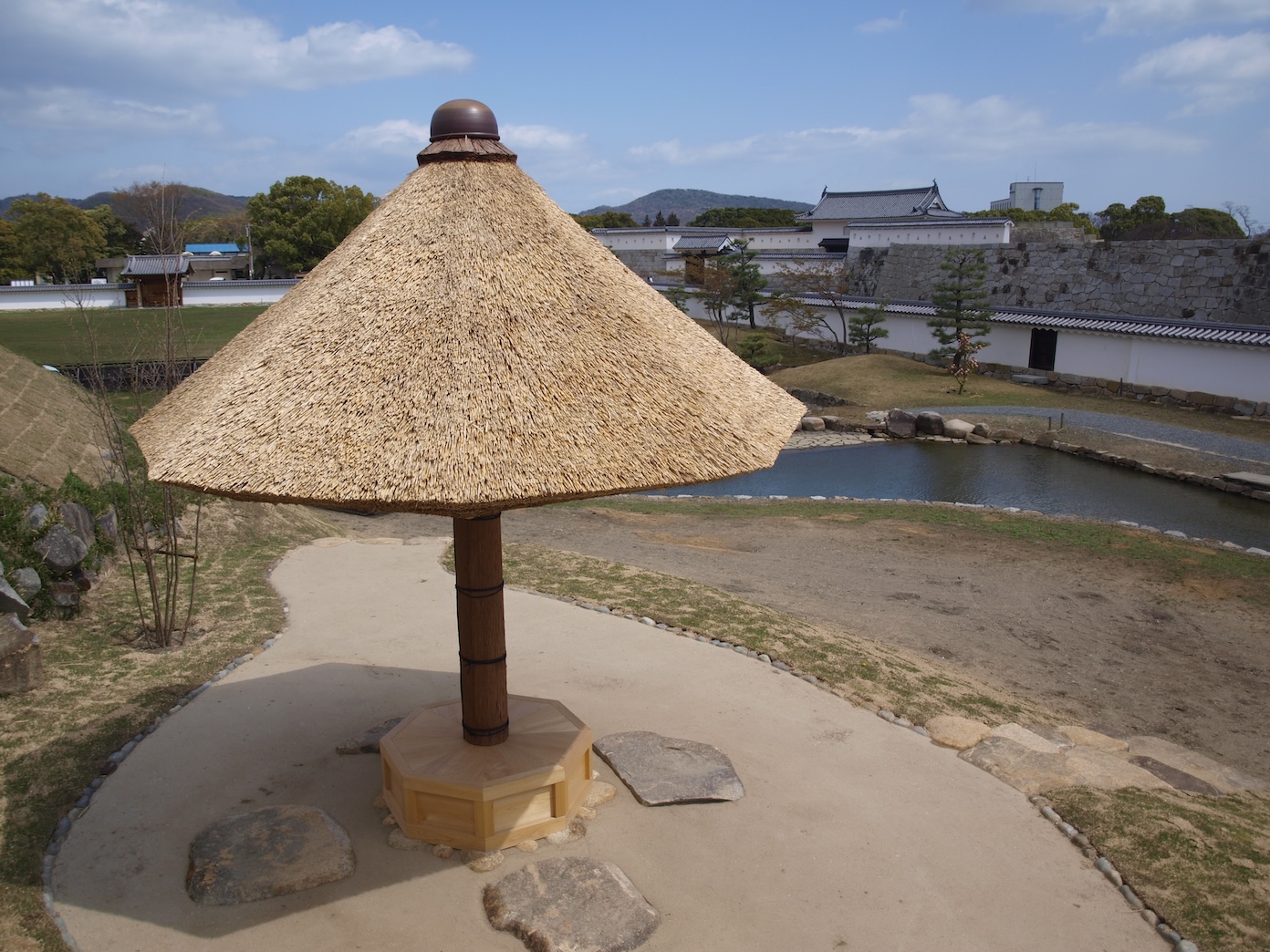 【Kasatei (Teahouse)】
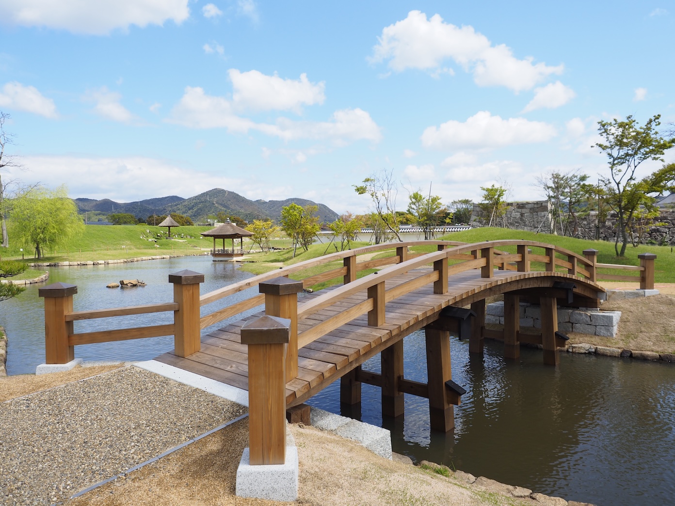
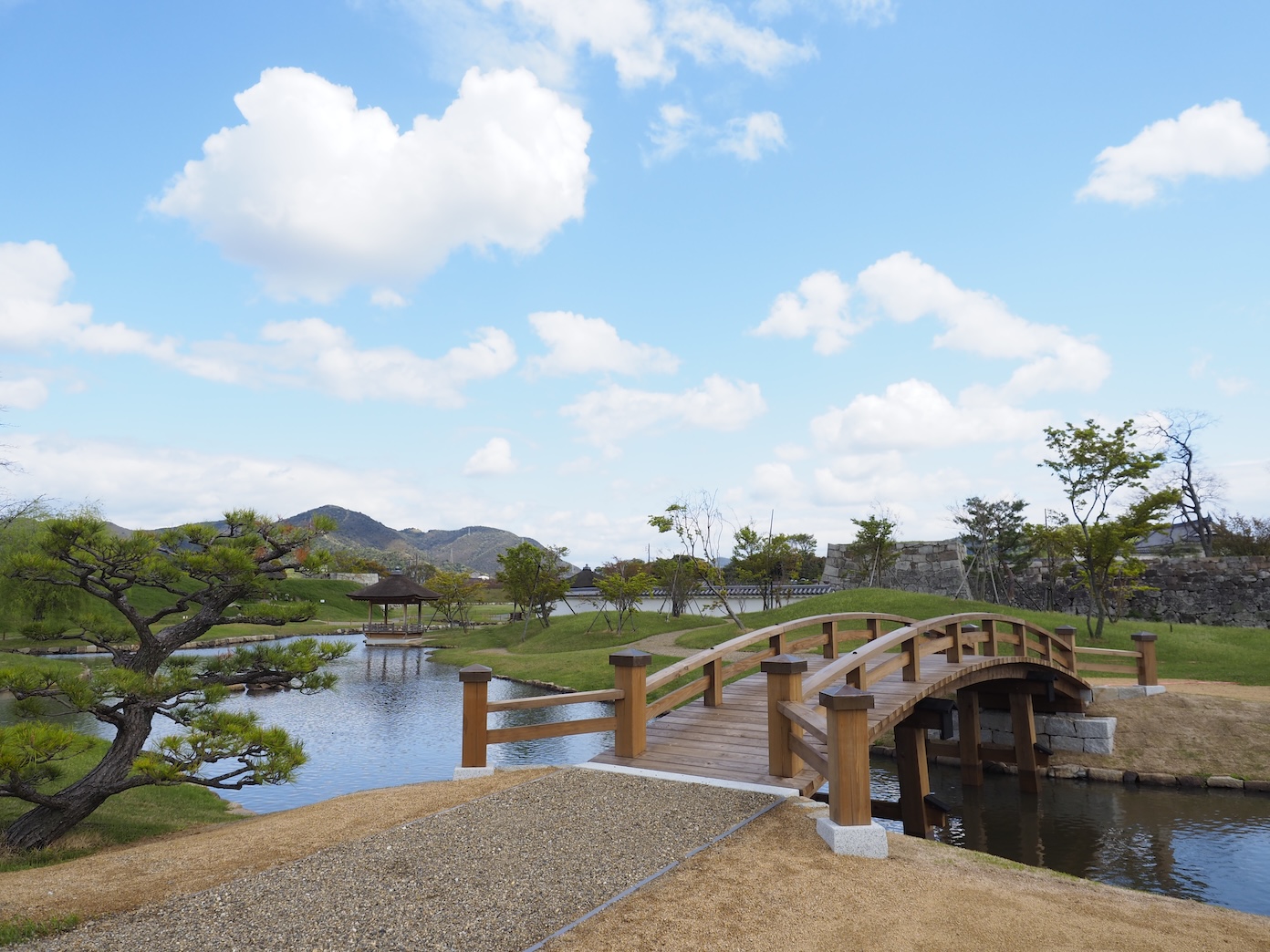 【Wooden Bridge】
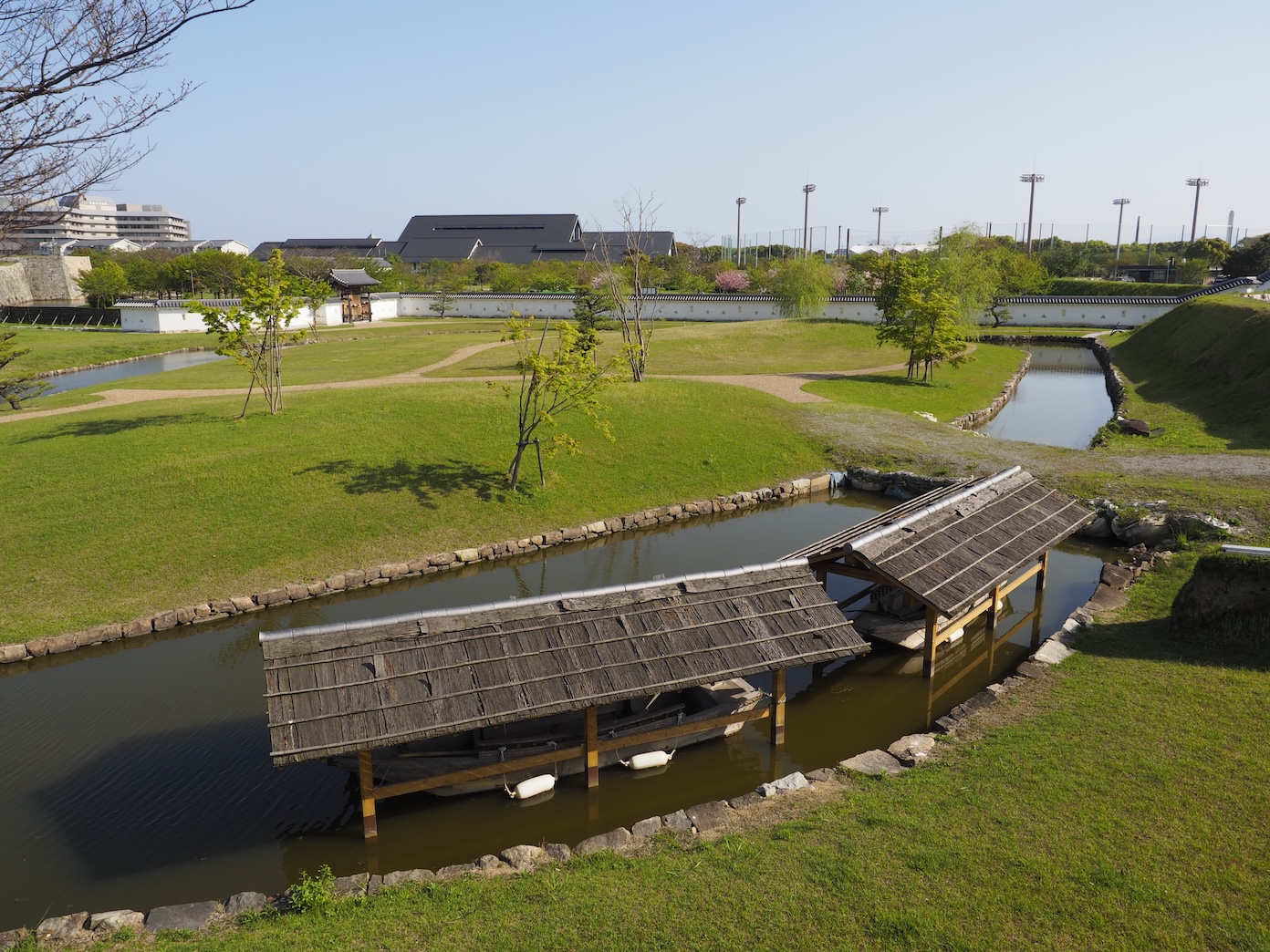 【Funaya (Boathouse)】
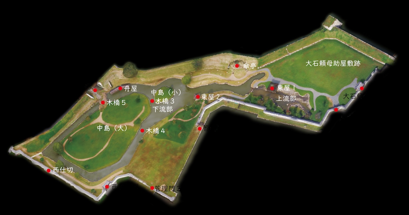 【Ninomaru Gardens Repairs】
 【Ōishi Tanomonosuke Residence Gate】
 【Ninomaru Garden Outer Gate】
 【Kanrimon Gate 2】
 【Wooden Bridge 4】
 【Kanrimon Gate 3】
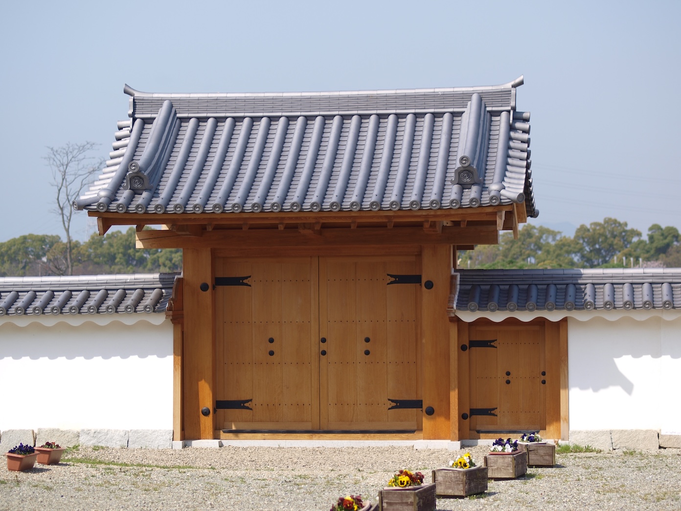
 【Nishishikirimon Gate】
Studying the Gate Sites
 【Old Photograph of Ninomarumon Gate (Negatives are Property of Kagakuji Temple)】This photograph was taken sometime between 1877 and 1886. You can see low, latticed stone walls. Behind the stone walls is a yaguramon-style gate.
 【Excavation of the Ninomarumon Gate Site】 The foundation of a low, latticed stone wall was found in front of the yaguramon-style gate, which additions had been made to. There is a good chance that these were changes ordered by Yamaga Sokō.
Ninomarumon Gate stood along the main route when traveling from the Sannomaru to the Ninomaru. The gate site was partially excavated in 2002. The layout of this area had been changed under the orders of Yamaga Sokō while he resided in Akō, and excavation efforts uncovered the foundation of a low stone wall that suggests changes had been made.
The sites of Mizutemon Gate, Nishinakamon Gate, and Nishishikirimon Gate were also excavated. Researchers found that Mizutemon Gate and Nishinakamon Gate were kōraimon-style gates, and Nishishikirimon Gate was a munamon-style gate. Nishishikirimon Gate and Nishinakamon Gate was restored during the repairs to Ninomaru Gardens.
 【Excavation of the Ninomaru Nishinakamon Gate Site】 This gate was located on the west end of the Ninomaru Gardens. Excavation of the gate site revealed an earth-paved bridge and its unique construction.
 Mizutemon Gate faced the Seto inland sea. There were steps right out front that led to an area where boats could dock.
Studying the Yagura Bases
While only a few studies have been done on the yagura (turret) bases at the Akō Castle Ruins, Ninomaru North Yagura Base and Ninomaru East Yagura Base were excavated.
Ninomaru North Yagura Base was dismantled and repaired during the restoration of the Ninomaru Gardens. As a result, it was revealed that a newer stone wall had been covering up an old stone wall connected to the yagura base. These stone walls undoubtedly existed before the Asano clan constructed the current Akō Castle, and the layout is similar to the Ikeda clan’s Kakiage Castle. These walls are important artifacts that require further study.
Ninomaru East Yagura Base was destroyed sometime after the Meiji period when the castle grounds were used as farmland and dirt was being gathered. It was excavated in 2018, where it was revealed that it had been destroyed. The remaining cornerstone at the base's center tells us this was a single-story yagura.
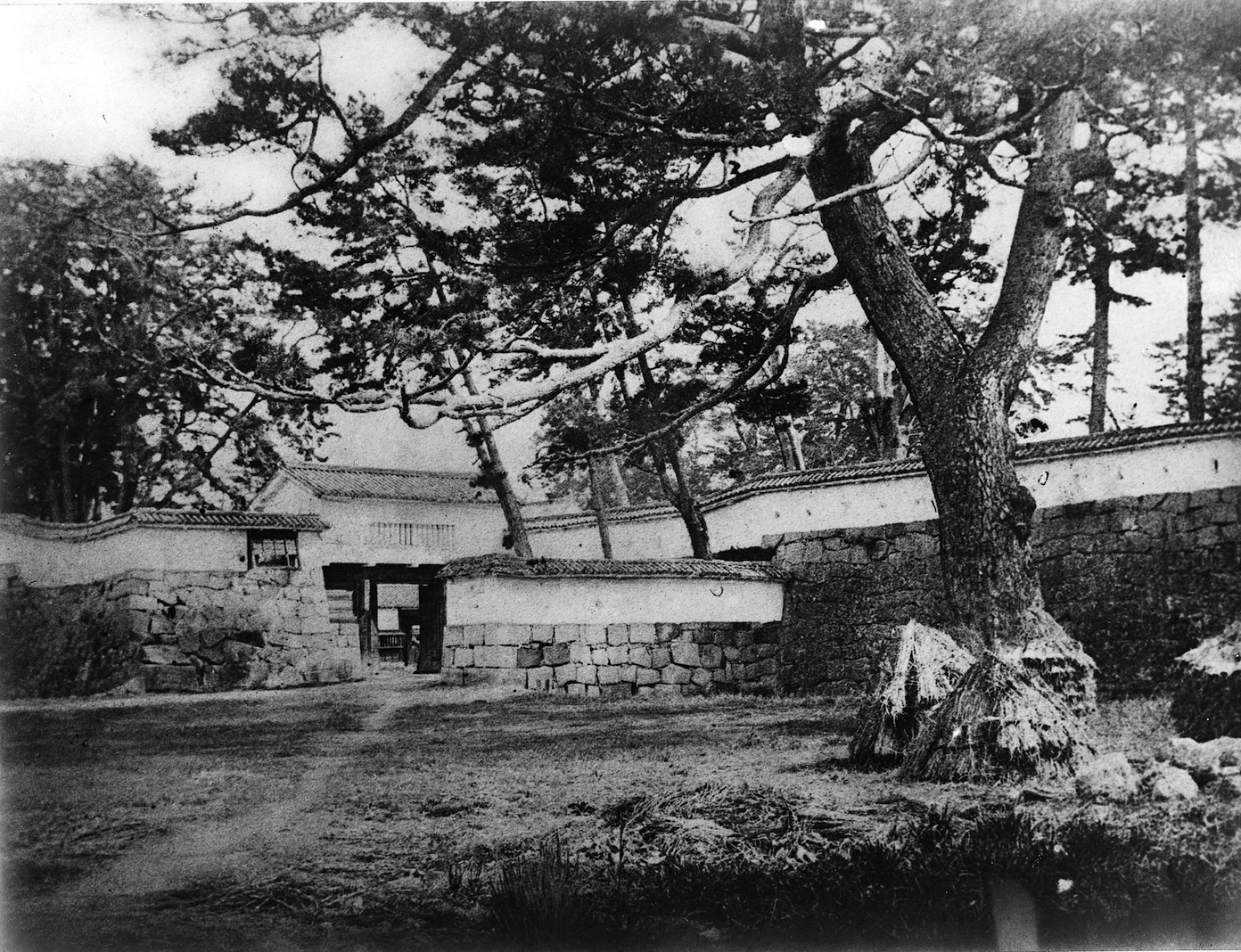
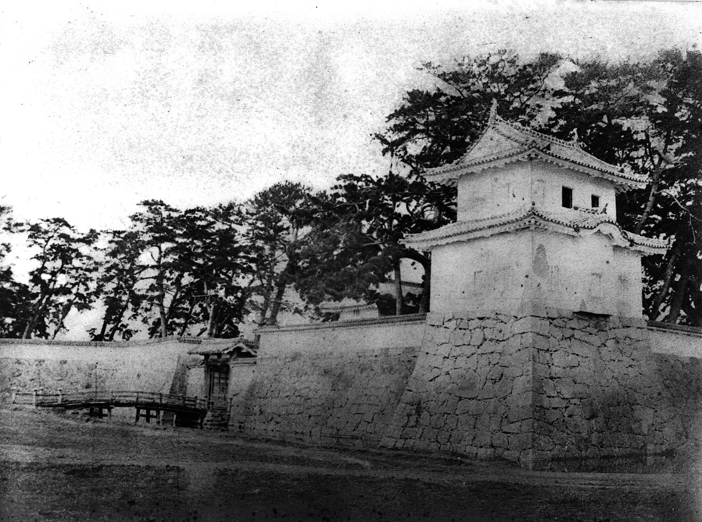
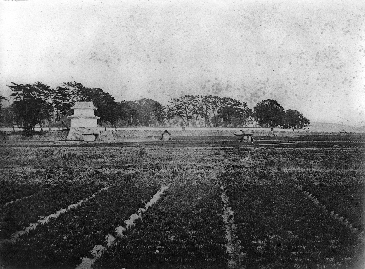 【Old Photograph of the Sannomaru Southwest Yagura and the Ninomaru Shiomi Yagura (Negatives are Property of Kagakuji Temple)】The yagura pictured in the front is the southwestern sumi-yagura (corner turret) of Ninomarumon Gate. The yagura pictured in the rear right is Shiomi Yagura. This photograph was taken from the western side of the castle sometime between 1877 and 1886.
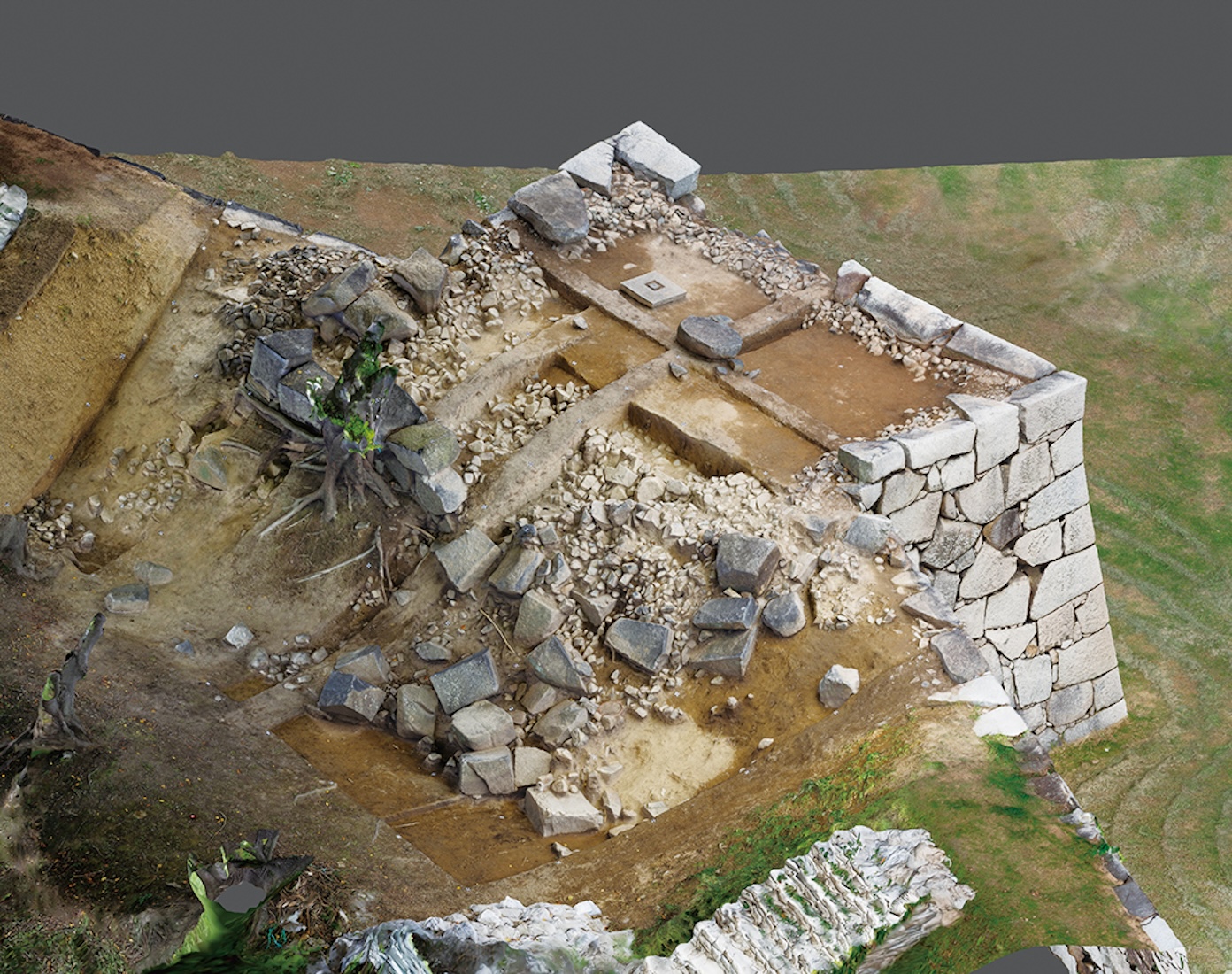 【Excavation of Akō Castle Ruins Ninomaru East Yagura Base (3D Model)】 This rendering depicts the area from the southwest. The foundation remains at the base’s center, but the west side (front side) has been heavily damaged.
Sannomaru
Jōgasū
According to Banshū Akōgunshi, this area was known as “Jōgasū.” During the Tensho era (1573 to 1593), Tsunami Hōin, a retainer of Ukita Hideie, came to Akō from Bizen Okayama. He then established a public office in the area that would become Kondō Genpachi’s residence during the rule of the Asano clan. It is said that later on, the public office of Tarumi Hanzaemon Katsushige, who was the local governor of Akō during the rule of the Ikeda clan, was established on the grounds of Okuno Shōgen’s residence, which was on the east side of Jōgasū.
 【Restoration of the Akō Castle Ruins Sannomaru and Edo Period Landscape】The Sannomaru faced the castle town, where samurai residences and machiya (townhouses that served as storefronts) stood. The Sannomaru had entrances in 3 different directions: Ōtemon Gate, Shimizumon Gate, and Shioyamon Gate. Ōtemon Gate led to the castle town, Shimizumon Gate to the granaries, and Shioyamon Gate to the samurai residences. Further, the pathways within the Sannomaru have barely changed since the Edo period. Currently, Akō Ōishi Shrine stands on the site of Ōishi Kuranosuke Yoshitaka’s residence. Very few structures from the Edo period remain, including the two nagayamon-style gates at the sites of Ōishi Yoshitaka and Kondō Genpachi’s residences.
The Sannomaru Layout
South of the castle were shallow tidelands (i.e., the Seto inland sea), and the eastern side faced Kumamigawa. These bodies of water provided natural defenses to the castle. The Sannomaru was constructed to defend the northern and western sides of the castle, thus protecting it from every direction.
At the north end of the Sannomaru were Ōtemon Gate, which led to the castle town to the north, and a masugata. The masugata (a square-shaped, defensive configuration) comprised a kōraimon-style gate and a yaguramon-style gate. Adjacent to the masugata was the imposing, two-story Ōte Yagura (turret).
Shimizumon Gate was constructed on the east side, facing Kumamigawa River and connecting to the granaries and docks. Shioyamon Gate was on the west side and was the “karametemon (back entrance gate).” Higata Gate was built in the southwest, facing the Seto inland sea. The Sannomaru also had 4 yagura built for defense. These yagura were placed strategically to face the castle town, Kumamigawa River, Seto inland sea, or neighbor the castle gates.
The Sannomaru walls were built in a complex zigzag pattern known as ore, which shows how war tactics heavily influenced its construction. The byōbu-ore to the west of Akō Ōishi Shrine are a prime example of this influence. The acute protrusions jutting out of the stone walls are a highlight of this area.
The Samurai Residences
The Sannomaru was home to the residences of several senior officials, including Ōishi Yoshitaka, the head chamberlain who had a stipend of 1,500-koku, Ōno Kurobē, a fellow chamberlain, and Kondō Genpachi, the son of Kondō Masazumi (the architect of Akō Castle).
The Sannomaru also had stables during the Asano clan’s rule, where horses could be kept. The lord of the castle appeared to have practiced horse riding at the riding ground in the Ninomaru.
However, an incident involving a sword attack led to the removal of the Asano clan and the start of the Mori clan’s rule. This came with a decrease in kokudaka, which made it difficult for the Mori clan to maintain the large-scale residences of the officials. The residences became shared among warriors. For example, Ōishi Yoshitaka’s residence was shared by 5 samurai.
Further, following the Meiji Restoration in 1872, Akō Castle was set to be abandoned. Around 1885, the castle gates and yagura were demolished, and the samurai residences were sold to civilians.
The Ōte Yagura
The Ōte Yagura in the Sannomaru has become a symbol of Akō Castle. The property of Akō Castle was sold to civilians after the Meiji Restoration. Aside from a few buildings, most of the castle was torn down. Decades later, there was a national movement to restore castles, starting with tenshu towers. Following this movement, the yagura and Ōtemon Gate (specifically the kōraimon-style gate) were rebuilt in 1955. Though the details differ from the original structures, these reconstructions still convey the majesty that Akō Castle had in the past.
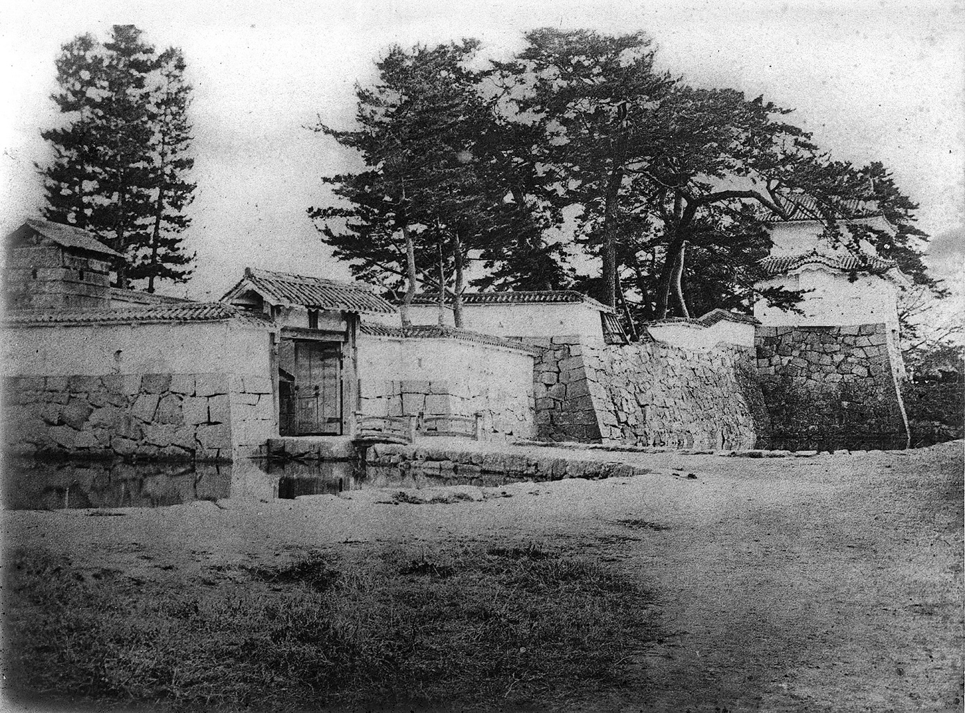
 【Old Photograph of the Sannomaru Ōte Yagura (Negatives are Property of Kagakuji Temple)】 This photograph was taken sometime between 1877 and 1886. Pictured along with the Ōte Yagura and Ōtemon Gate is a wooden bridge built over the outer moat of the Sannomaru. This photograph captures what the area looked like during the Edo period. Looking to the rear left of the yagura, you can see the upper level of the yaguramon-style gate.
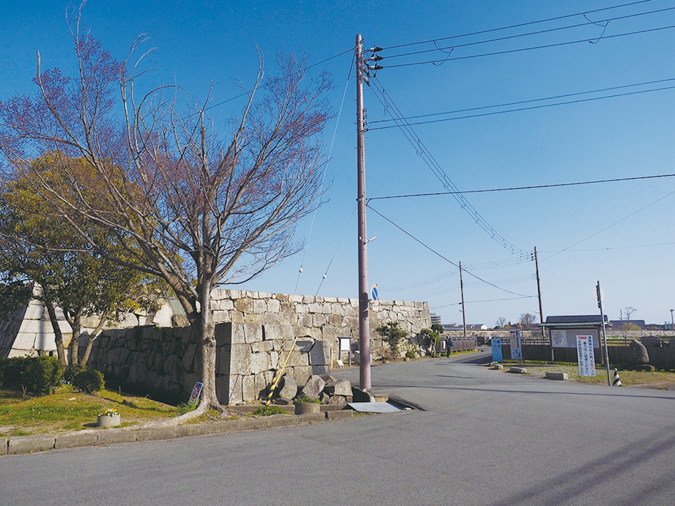
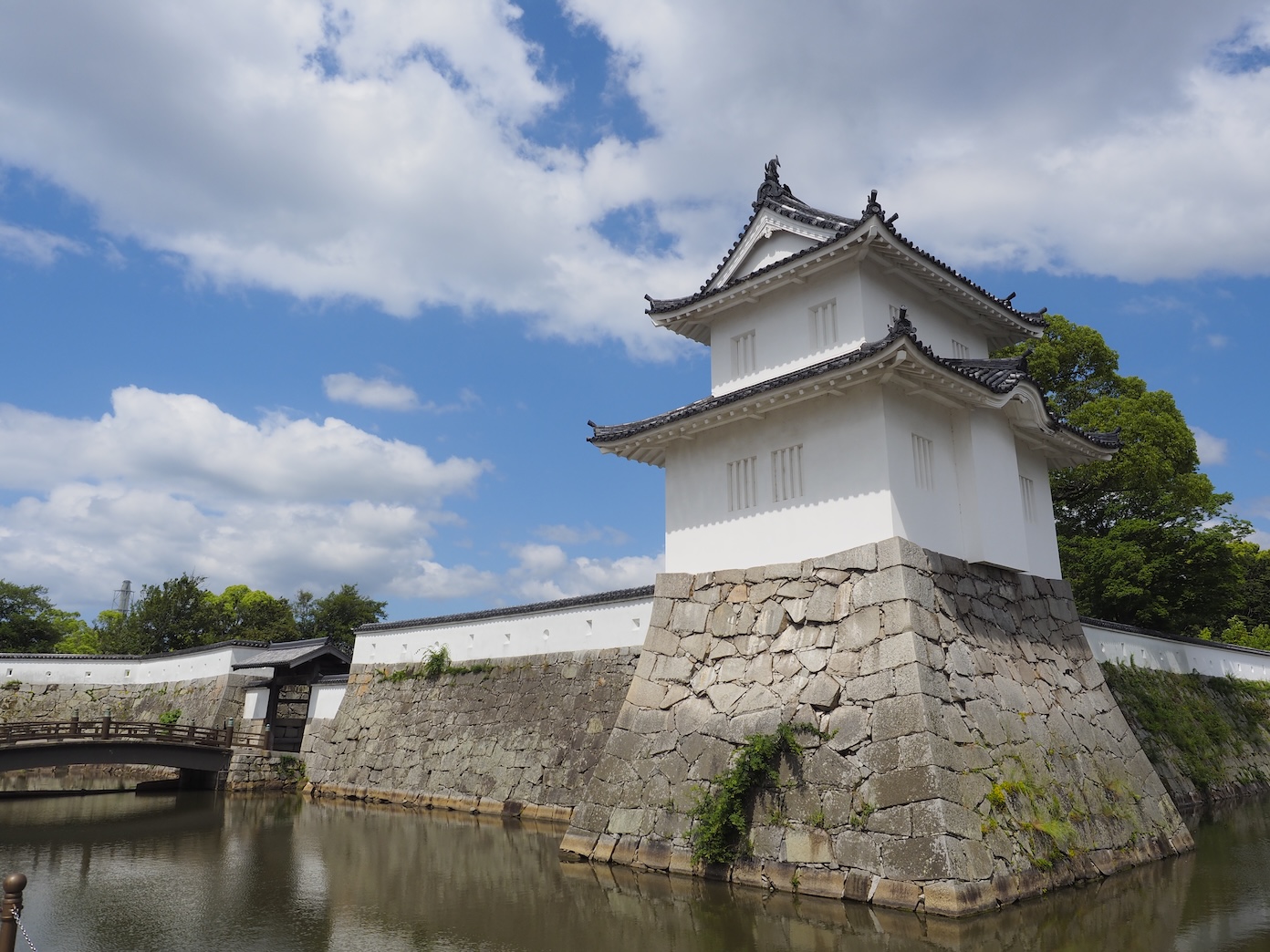 【The Sannomaru Ōte Yagura at the Akō Castle Ruins (Present-Day) 】The current yagura was rebuilt in 1955. There is a slight difference in the placement of the windows. The stone walls have survived in their original state and show no signs of being repaired.
Studying the Ōtemon Gate Masugata
The masugata of the Sannomaru’s Ōtemon Gate is an exceptionally secure structure among the defensive constructions within Akō Castle. First, the outer moat surrounding the area is shallow, making it impossible to hide underwater, and thick with mud, making it difficult to traverse. This means that the only way to cross the outer moat of the Sannomaru was to cross the taikobashi-style bridge. Even if you successfully made it past the first part of Ōtemon Gate, the kōraimon-style gate, you would also have to get through the yaguramon-style gate, where bullets or arrows would be shot at you from three different directions. If you somehow survived and made it past the yaguramon-style gate, along the U-shaped path to the castle was a mushadamari (a gathering spot for soldiers) where guards were on standby. As you can tell, the configuration of the castle made it quite challenging to launch a frontal assault.
The masugata was partially renovated in 1886. In 2001, it was restored to its original state based on researchers’ findings from excavation efforts in 2000 and 2001.
 【Excavation of the Akō Castle Sannomaru Ōtemon Gate Masugata Site 】The castle walls were found to have been destroyed in later years.
 【Excavation of the Surrounding Area of Akō Castle Sannomaru Ōtemon Gate 】
This image shows how Old Akō Waterworks supply lines traveled under Ōtemon Gate.
【Excavation of the Surrounding Area of Akō Castle Sannomaru Ōtemon Gate 】
This image shows how Old Akō Waterworks supply lines traveled under Ōtemon Gate.
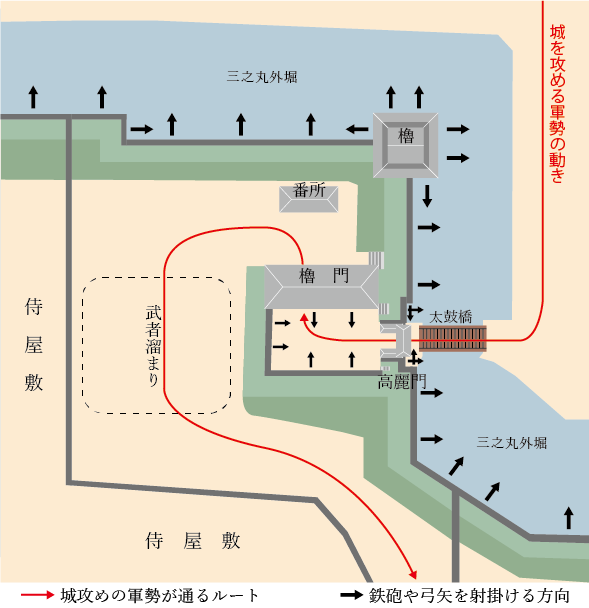 【Estimation of Defenses at the Akō Castle Sannomaru Ōtemon Gate Masugata Site】Ōtemon Gate, the entrance to Akō Castle, comprised 2 gates, a guardhouse, and a masugata, which created a significantly detoured path into the castle. If enemy forces wanted to get through Ōtemon Gate, they would be slowed down by the frequent turns and changing width of the path. While dealing with this difficult path, they would be attacked with arrows or bullets from various directions. The castle also defended itself by having guards on standby at a mushadamari (a gathering spot for soldiers), which prepared them to have the advantage over the thinned-out forces that passed the yaguramon-style gate.
Shioyamon Gate
Shioyamon Gate was the karametemon (back entrance gate) that faced the samurai residences in the castle town. This gate was an exceptionally important part of Akō Castle’s defenses. Though Shioyamon Gate only comprises one kōraimon-style gate, it has a masugata configuration like Ōtemon Gate. There haven’t been any excavation efforts at this site, so we don’t know the specifics of its construction. Despite the lack of research, the gate can be recreated using old photographs from the Meiji period.
 【Old Photograph of the Sannomaru Shioyamon Gate (Negatives are Property of Kagakuji Temple)】This photograph was taken sometime between 1877 and 1886. Past the kōraimon-style gate pictured here, the path would curve immediately to the right, creating a masugata configuration. Additionally, there was a two-story yagura that allowed the castle forces to attack enemies from the side. On the left side is a taiko-yagura (drum turret).
 【The Akō Castle Sannomaru’s Shioyamon Gate (Present-Day)】This photo was taken at the same angle as the photo above. Parts of the gate and adjacent stone walls have been removed, making it difficult to imagine what the gate looked like in the past. By comparing the present-day gate to old photographs, we can get an impression of its original state.
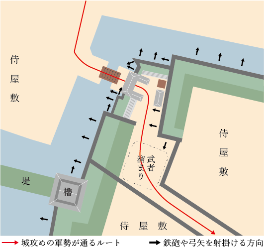 【Estimation of Defenses at the Akō Castle Sannomaru’s Shioyamon Gate 】Shioyamon Gate comprised only one gate, however it still had a masugata configuration. Additionally, the bridge over the outer moat and the path within the masugata were both much narrower than that of Ōtemon Gate. There were also samurai residences within the castle grounds, and it was undoubtedly difficult to penetrate. Because the area of Shioyamon Gate hasn’t been excavated, the diagram includes inferences on the castle’s defenses.
 【Shioyamon Gate (Left) and Shimizumon Gate (Right) as Depicted in ”Diagram of Akō Castle Waterworks”(Property of Akō City Board of Education)】This diagram is estimated to be from the late Edo period. It clearly depicts the locations of guardhouses and stairs.
Excavation of the Shimizumon Gate Site
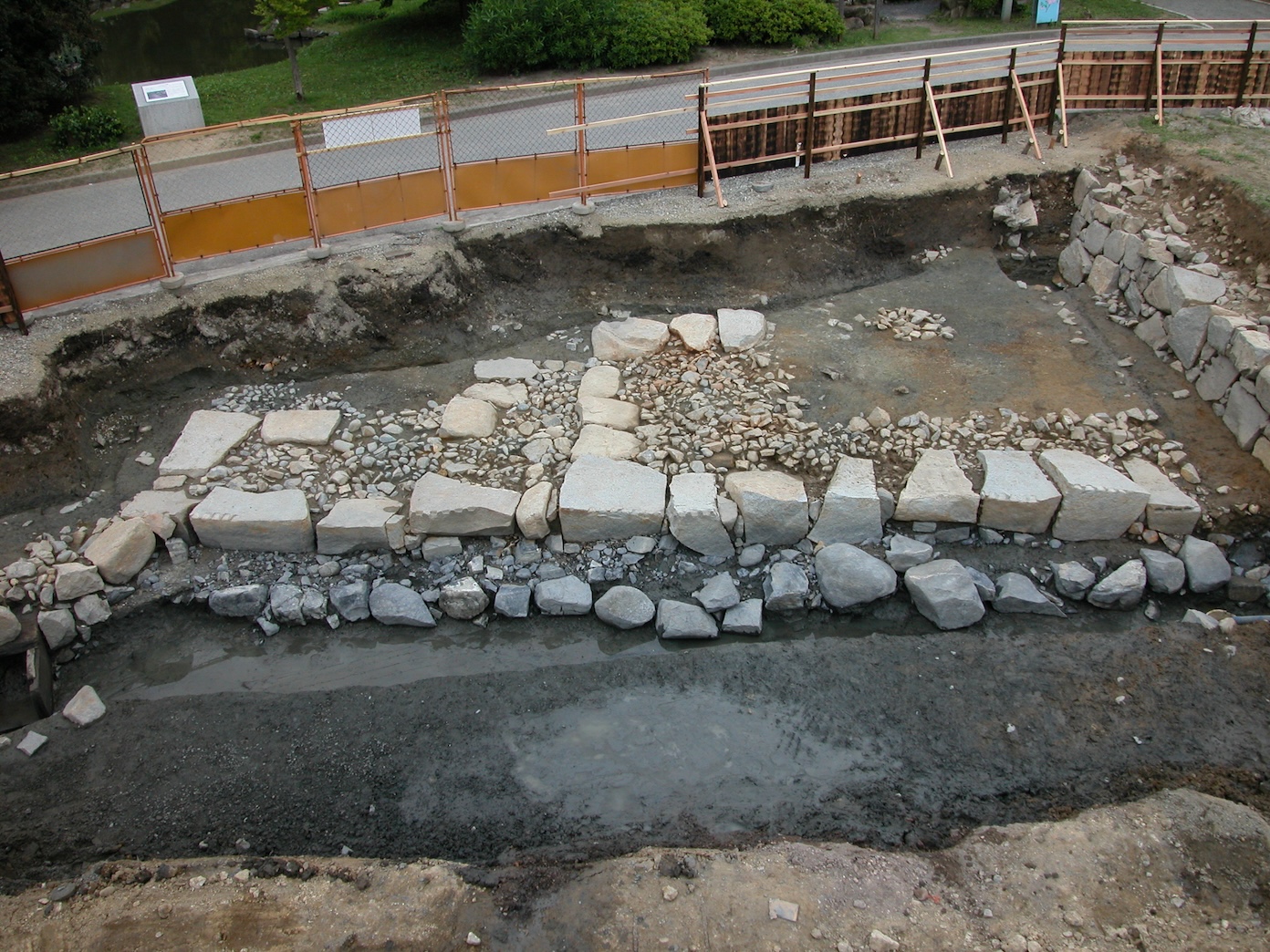
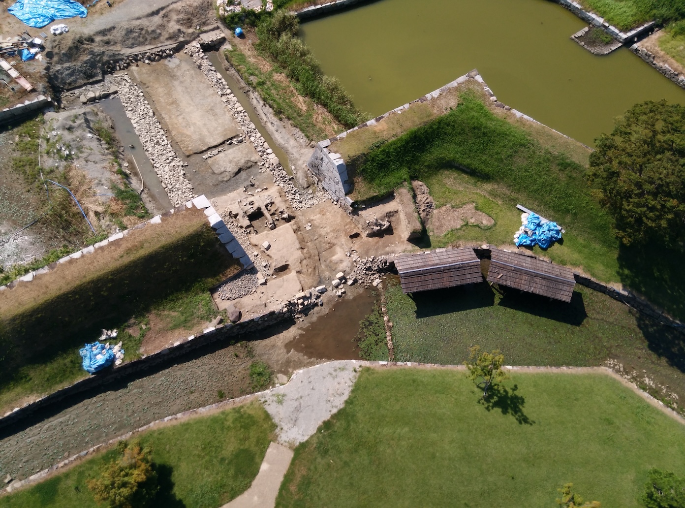
Shimizumon Gate faced the east side of Akō Castle, Kumamigawa River (now Kariyagawa River), granaries, and docks. There was a small wooden bridge built over the area where the Honmaru and Sannomaru’s outer moats connected. From here, people would enter the castle through the gate. According to maps, there were low stone walls arranged to block the path past the entrance, which provided a visual barrier. Though excavation efforts didn’t uncover parts of the gate, researchers were able to gain insight into the stone foundation of the wooden bridge.
 【Excavation of the Sannomaru’s Shioyamon Gate Site】The outer moats of the Honmaru and Sannomaru connected. Across the moat was a wooden bridge.
 【Shioyamon Gate as Depicted in ”Diagram of Akō Castle Waterworks”(Property of Akō City Board of Education)】This diagram is estimated to be from the late Edo period. It clearly depicts the locations of guardhouses and stairs.
Ōishi Kuranosuke Yoshitaka’s Residence
As it was the home of a chamberlain, Ōishi Kuranosuke Yoshitaka’s residence was located immediately past the entrance of Ōtemon Gate, and was a part of the castle’s defenses. However, after the dispossession of the Asano clan when the Mori clan gained control of Akō, managing this massive lot became difficult. It is said that several warriors shared the living quarters of the gate. However, in 1729, the main residence burned down in an accidental fire. The remaining lot and garden pond became a manufacturing site for hansatsu, a paper currency for use within the domain. The nagayamon-style gate that had barely survived went through major repairs in 1856.
In the Meiji period, the castle property was sold off to civilians. During this time, Senkei, an oshō (Buddhist priest) at Kagakuji Temple, purchased and preserved the nagayamon-style gate. This preservation led to Ōishi Shrine being built here in 1912.
In 1907, the mayor of Akō City led an initiative that established the Ōishi Residence Preservation Committee. In 1923, the “Ōishi Yoshitaka Residence Site” was designated a National Historic Site. However, the nagayamon-style gate, which was being repaired intermittently until 1966, hasn’t received a designation.
In 1977, there was a technical dismantling and repair of the gate that made use of old materials, and the gate was restored to its appearance in 1856. Despite the complicated history of the nagayamon-style gate, this structure from the Edo period is a valuable relic of the castle.
 【”Layout of Samurai Residences Within Akō Castle” (Property of Kagakuji Temple)】This diagram is a copy made in 1931 based on plans provided by the Tatsuno Domain, who had been overseeing Akō when Nagai Nagahiro became the lord of the domain in 1702. The area in white is the Sannomaru. Most of the paths within the castle remain to this day, and you can visit the site of the residences.
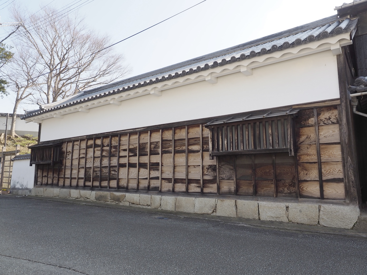
 【The Ōishi Yoshitaka Residence Site Nagayamon-style Gate】Though it has been repaired several times, this gate remains a valuable structure from the Edo period.
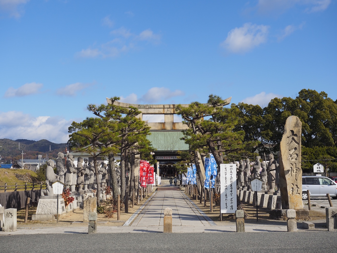 【Akō Ōishi Shrine】The treasures offered to Akō Shrine prior to its merge with Ōishi shrine are also stored here.
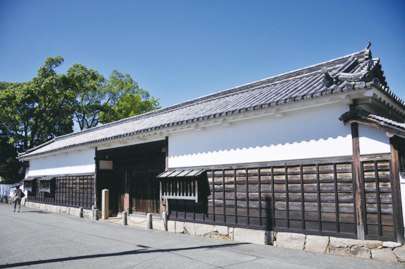
The Kondō Genpachi Residence Site Nagayamon-style Gate
Another structure at Akō Castle that has survived since the Edo period is the nagayamon-style gate at the site of Kondō Genpachi’s residence, which is across from the nagayamon-style gate at the site of Ōishi Yoshitaka’s residence. Kondō Genpachi Masanori was the son of Kondō Saburozaemon Masazumi, the master of war tactics and chamberlain who was the architect of Akō Castle. Kondō Genpachi also studied Kōshū-ryū war tactics and held the position of bangashira, the high-ranking position of bangashira (a military official) with a stipend of 1,000-koku.
Roughly a third of the 18-ken (~36m) long nagayamon-style gate of the Kondō home remains. In the following era of the Mori clan’s rule, the gate was renovated to accommodate multiple residents, similar to the nagayamon-style gate of Ōishi Yoshitaka’s residence.
In 1998, the city designated the gate as an Important Cultural Property. Part of the gate was torn down, and researchers began excavating the area. Repairs to the gate finished in 1999.
 【The Kondō Genpachi Residence Site Nagayamon-style Gate 】Only part of the gate remains today. This gate was originally 18-ken (~36m) long.
Maps of Akō Castle
Details of Kakiage Castle
 【Enlarged View of the Residential Compound from ”Map of Akō Castle Town under Commissioner Matsudaira’s Domain” (Property of Akō City Museum of History)】
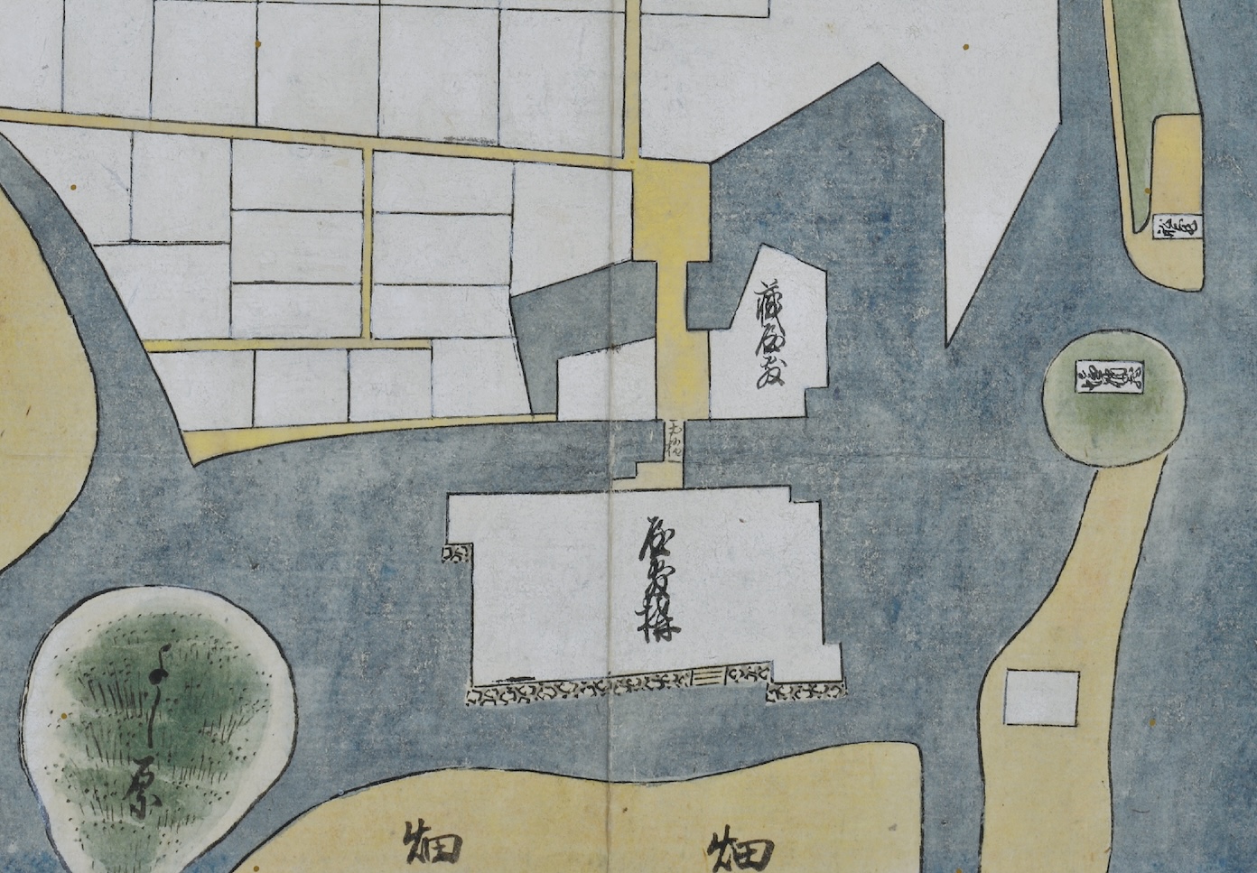
Before Akō Castle was built, the small scale “residential compound (Kakiage Castle)” was built during the rule of the Ikeda clan. Excavation efforts have revealed that Kakiage Castle stood where the Akō Castle Honmaru stands today.
Upon enlarging a map that depicts the area at the time, ”Map of Akō Castle Town under Commissioner Matsudaira’s Domain” (see above), we can see that the residential compound was a rectangular structure surrounded by the sea. Portions of the northwestern and southeastern walls jutted out. In contrast, the northeastern corner was concave to form a yokoya gakari. Illustrated on the north side is an earth-paved bridge leading to a kurayashiki (a combined storehouse and residence). Illustrated on the south side are stone stairs, which allowed for boats to dock right alongside the compound.
The Castle Grounds (Genroku Era)
 【Reprint of “Layout of Samurai Residences Within Akō Castle” (From Ōishi Jinja-zō Akō-jō Uketori Monjo, edited by Iio Kuwashi, 1993.) 】
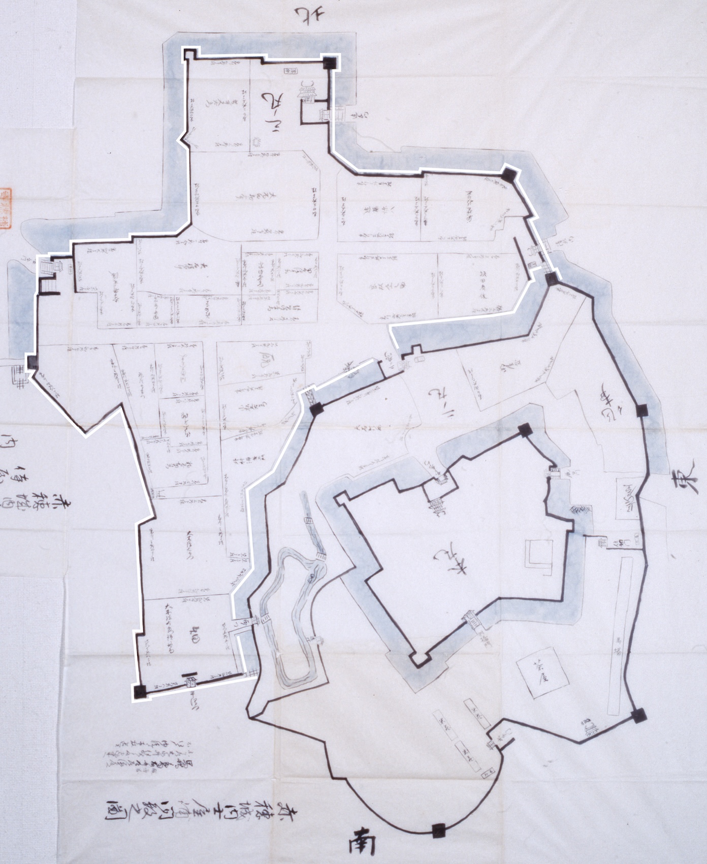
In September of 1702, control of the Akō Domain transferred from the Asano clan to Nagai Nagahiro. On November 4, Akō Castle was surrendered and the Tatsuno Domain, who was overseeing Akō, submitted plans of the castle. “Layout of Samurai Residences Within Akō Castle” is a copy created in 1931 of said plans.
This diagram includes details such as the names of those living in the samurai residences within the castle grounds, as well as the size of the lots. The various facilities within the castle grounds are also depicted in detail, making this diagram an important document that tells us what the castle was like at the time. Among the existing maps of Akō Castle, only a relatively small number label the facilities within castle grounds. There are very few diagrams that depict the size and shape of the pond and bridge in the northwestern area of the Ninomaru (the Ninomaru Gardens). Because this diagram includes such details, it is an incredibly important resource.
Another interesting part of this map is that Ōishi Tanomonosuke Yoshishige’s residence is still depicted despite his passing in 1683, meaning the building had been left standing.
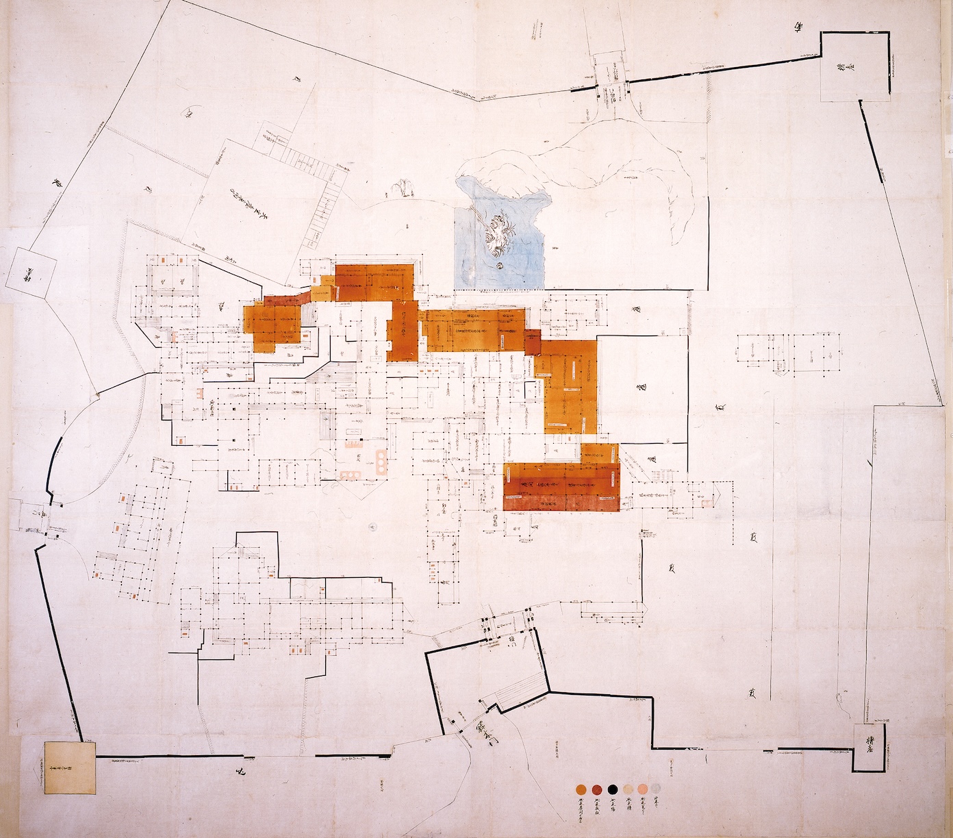
Map of the Honmaru Palace
We know of three maps depicting the Honmaru palace.
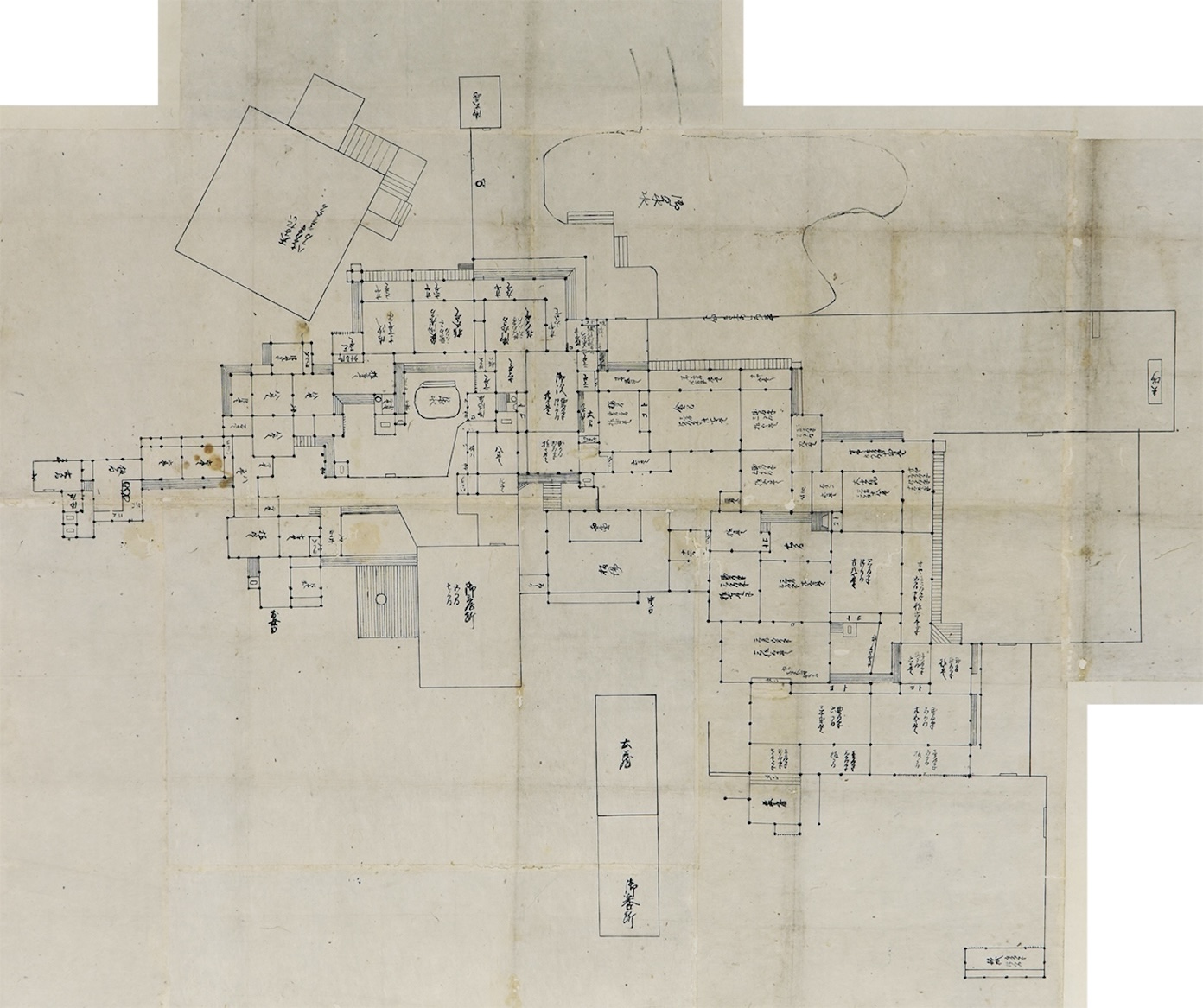
First is “Diagram of the Akō Castle Honmaru”, which was created in 1701 when Akō Castle was surrendered to the Wakisaka clan of Tatsuno Domain following an incident with a sword. Next is “Map of the Akō Castle Palace (Spare)”. This map was owned by the Nagai clan, who ruled over Akō Domain for roughly 4 years following the dispossession of the Asano clan. The date of its creation is unknown.
 【“Diagram of the Akō Castle Honmaru” (Property of Tatsuno Municipal History and Culture Museum)】The Wakisaka clan of Tatsuno Domain created this map during the surrender of Akō Castle. The map features a detailed layout of the Honmaru. The orientation of the Honmaru indicates that the bottom is the north side.
 【“Map of the Akō Castle Palace (Spare)” (Property of the Historiographical Institute, University of Tokyo)】This map was owned by the Nagai clan, who ruled over Akō Domain from 1702 to 1706. It is believed to have been created after the aforementioned diagram, and the two have slight differences in the floorplans.
The floorplans of both diagrams are consistent for the most part. They of course share the layout of having an omote (the area where the lord conducts official business), a nakaoku(the residence of the lord), and an oku (where the lord’s family lived). The floorplans of the structures are also nearly identical. One area that has changed is the sectioning of the rooms, which tells us that this map is likely the newer of the two.
Let’s take a closer look at “Diagram of the Akō Castle Honmaru”. This diagram is incredible elaborate and includes not only the floor plan but even the shapes of the pillars, which are expressed using the symbols “●” and “■.” The “●” pillar is used in the nakaoku, the residence of the lord, and the oku, where the lord’s family lived. In contrast, the “■” pillar is mainly used in the omote, which was used for official business. We can also see a difference in the placement of pillars between the omote and oku. Because of this, it is believed that the buildings were constructed at different times. Before Asano Naganao built Akō Castle, the residential castle of the Ikeda clan Kakiage Castle stood on the grounds of the Honmaru. There are records that Ikeda Masatsuna made additions in 1615 (building a parlor room, an entryway, a shikidai entryway step, and a dozō storehouse). In 1631, Ikeda Teruoki completed a gold-accented room, several gates, a sumi-yagura and stables. A majority of the additions made by Masatsuna remained in the omote during the Asano clan’s rule. It would be strange for Asano Naganao to have torn all of this down and rebuilt the castle when he became the lord 30 years later. In other words, the “■” pillars in “Diagram of the Akō Castle Honmaru” are likely from the Ikeda clan’s castle, and buildings with the round “●” pillars are believed to have been newly built by the Asano clan.
Lastly, we have a map of the lord’s palace during the rule of the Mori clan (pictured below).
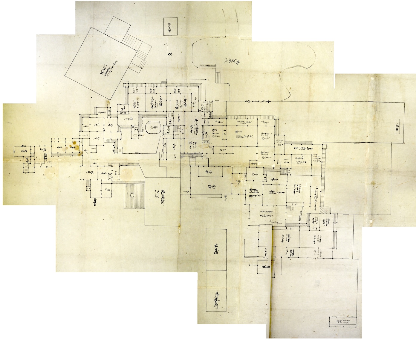
 【”Palace Floor Plan of the Akō Castle Honmaru” (Property of Akō City Museum of History)】This diagram depicts the Honmaru palace after it was rebuilt in 1861. Compared to the plans from the Genroku era, we can see that some renovations have been made.
When the school building of Akō Ordinary Higher Elementary School was demolished, the munafuda (a sign staked to the ridgepole that includes information such as the builder’s name, reason for construction, etc.) revealed that the building had been a relocated reconstruction of the lord’s palace built in 1878. During this time, it was also revealed that the palace had gone through renovations in 1861. This floorplan is speculated to depict the palace following the renovations in 1861. Compared to the diagram from the Asano clan’s rule, it appears that the Mori clan’s palace was sized-down (see diagram above).
-“Diagram of the Akō Castle Honmaru” (Asano period/1701) (Property of Tatsuno Municipal History and Culture Museum)
-”Palace Floor Plan of the Akō Castle Honmaru” (Mori period) (Property of Akō City Museum of History)
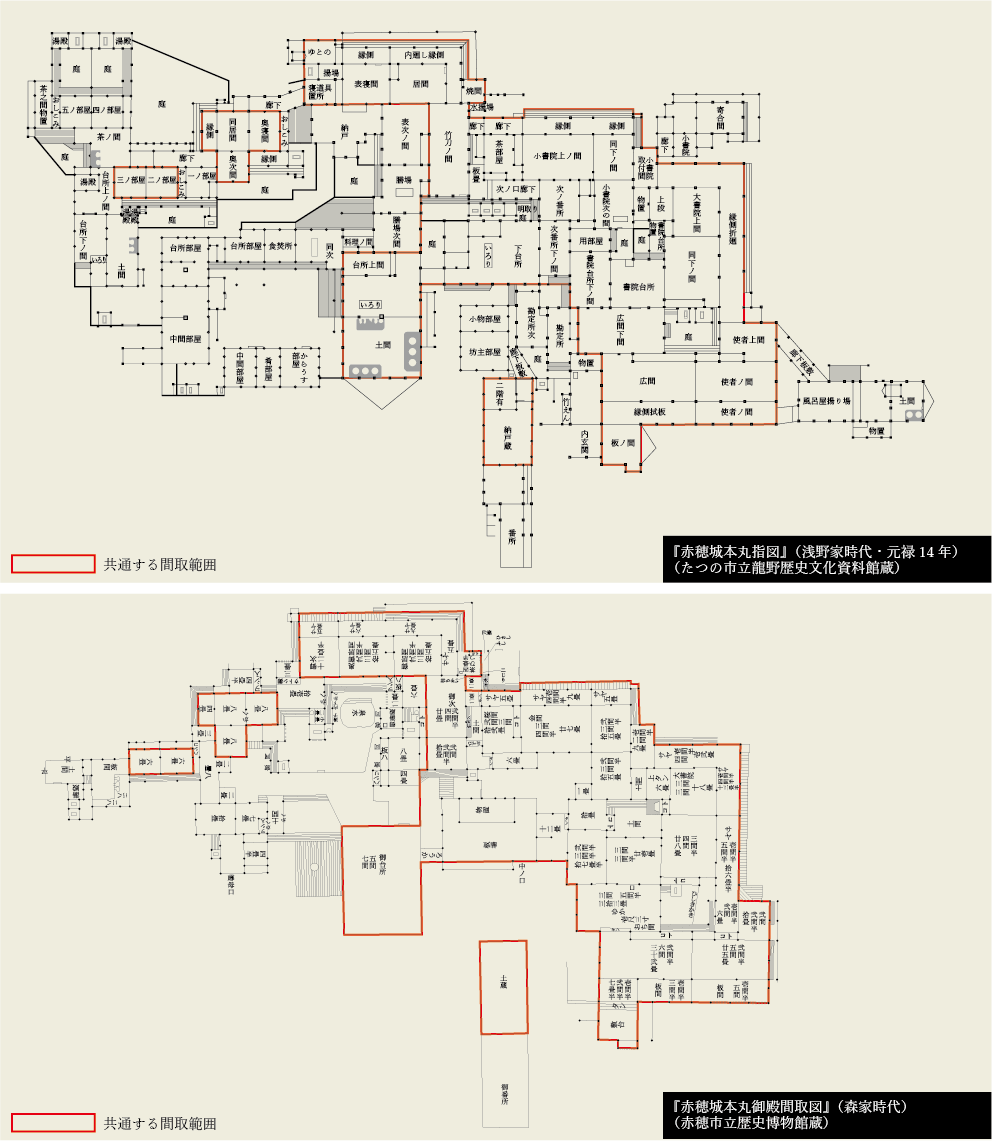 【Comparison of “Diagram of the Akō Castle Honmaru” (Top Diagram. Property of Tatsuno Municipal History and Culture Museum) and ”Palace Floor Plan of the Akō Castle Honmaru” (Bottom Diagram. Property of Akō City Museum of History)】
Specifically, the structure of the western half of the Asano palace (in other words, the omote where business was conducted) was left untouched, while the floorplan inside was changed. The kitchen and lord’s room remained the same, while the large omote (where the lord’s family and concubines lived) was demolished and replaced with a new building. These renovations are believed to be motivated by the fact that the Asano clan’s palace was more than the Mori clan needed since their kokudaka was much less than the Asano clan’s. The Mori clan had a kokudaka of 20,000-koku, while the Asano clan had a kokudaka of over 50,000 koku.
Akō Ordinary Higher Elementary School was torn down in 1928. In other words, the structures built by the Ikeda clan during the Edo period might have survived until the early Shōwa period.